You are here: Home > Network List > TA - USArray Transportable Network (new EarthScope stations) Stations List
> Station J19A Crowheart, WY, USA > Earthquake Result Viewer
J19A Crowheart, WY, USA - Earthquake Result Viewer
| Earthquake location: |
Off East Coast Of Kamchatka |
| Earthquake latitude/longitude: |
52.5/159.8 |
| Earthquake time(UTC): |
2010/07/30 (211) 03:56:13 GMT |
| Earthquake Depth: |
23 km |
| Earthquake Magnitude: |
6.1 MB, 6.3 MS, 6.3 MW, 6.3 MW |
| Earthquake Catalog/Contributor: |
WHDF/NEIC |
|
| Network: |
TA USArray Transportable Network (new EarthScope stations) |
| Station: |
J19A Crowheart, WY, USA |
| Lat/Lon: |
43.26 N/109.05 W |
| Elevation: |
1782 m |
|
| Distance: |
57.9 deg |
| Az: |
59.591 deg |
| Baz: |
313.797 deg |
| Ray Param: |
0.0631831 |
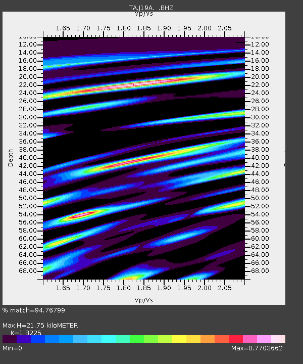
| Estimated Moho Depth: |
21.75 km |
| Estimated Crust Vp/Vs: |
1.82 |
| Assumed Crust Vp: |
6.161 km/s |
| Estimated Crust Vs: |
3.38 km/s |
| Estimated Crust Poisson's Ratio: |
0.28 |
|
| Radial Match: |
94.76799 % |
| Radial Bump: |
390 |
| Transverse Match: |
91.09456 % |
| Transverse Bump: |
382 |
| SOD ConfigId: |
319893 |
| Insert Time: |
2011-01-05 14:31:26.330 +0000 |
| GWidth: |
2.5 |
| Max Bumps: |
400 |
| Tol: |
0.001 |
|
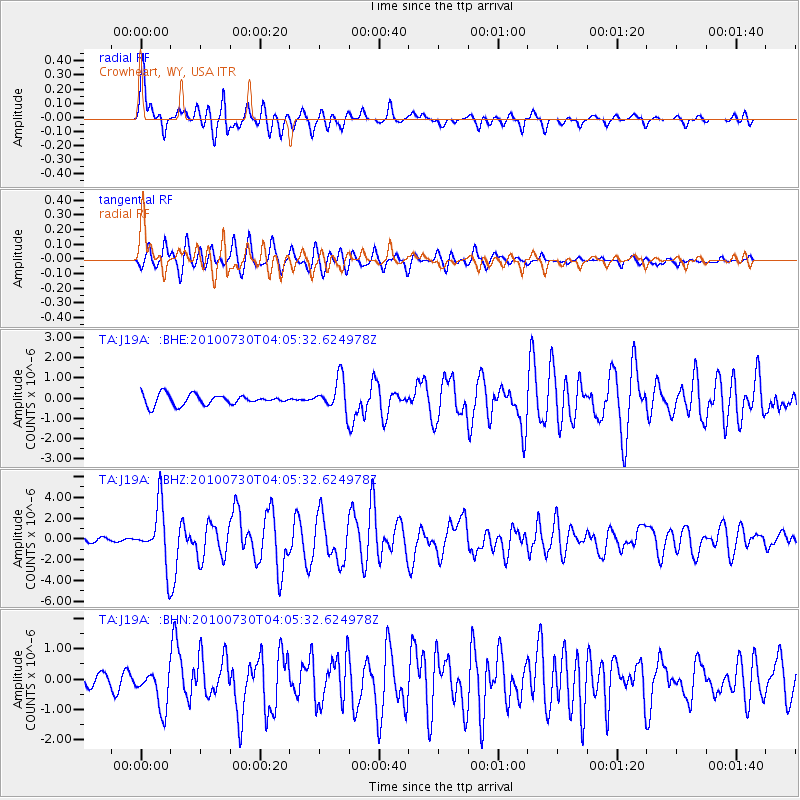
Signal To Noise
| Channel | StoN | STA | LTA |
| TA:J19A: :BHZ:20100730T04:05:32.624978Z | 13.897308 | 2.803682E-6 | 2.0174281E-7 |
| TA:J19A: :BHN:20100730T04:05:32.624978Z | 3.4544256 | 6.495386E-7 | 1.8803085E-7 |
| TA:J19A: :BHE:20100730T04:05:32.624978Z | 3.135479 | 7.9739647E-7 | 2.5431407E-7 |
| Arrivals |
| Ps | 3.0 SECOND |
| PpPs | 9.5 SECOND |
| PsPs/PpSs | 13 SECOND |


