You are here: Home > Network List > TA - USArray Transportable Network (new EarthScope stations) Stations List
> Station J20A Shoshoni, WY, USA > Earthquake Result Viewer
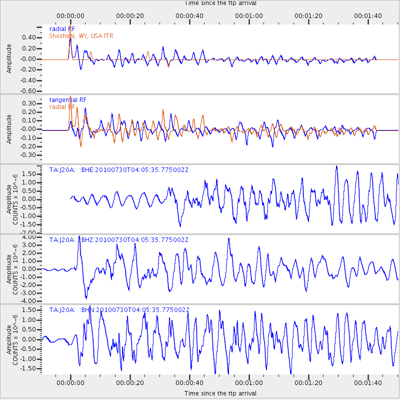
J20A Shoshoni, WY, USA - Earthquake Result Viewer
*The percent match for this event was below the threshold and hence no stack was calculated.
| Earthquake location: |
Off East Coast Of Kamchatka |
| Earthquake latitude/longitude: |
52.5/159.8 |
| Earthquake time(UTC): |
2010/07/30 (211) 03:56:13 GMT |
| Earthquake Depth: |
23 km |
| Earthquake Magnitude: |
6.1 MB, 6.3 MS, 6.3 MW, 6.3 MW |
| Earthquake Catalog/Contributor: |
WHDF/NEIC |
|
| Network: |
TA USArray Transportable Network (new EarthScope stations) |
| Station: |
J20A Shoshoni, WY, USA |
| Lat/Lon: |
43.35 N/108.08 W |
| Elevation: |
1500 m |
|
| Distance: |
58.3 deg |
| Az: |
58.938 deg |
| Baz: |
314.115 deg |
| Ray Param: |
$rayparam |
*The percent match for this event was below the threshold and hence was not used in the summary stack. |
|
| Radial Match: |
76.37058 % |
| Radial Bump: |
400 |
| Transverse Match: |
80.23684 % |
| Transverse Bump: |
400 |
| SOD ConfigId: |
319893 |
| Insert Time: |
2011-01-05 14:31:29.006 +0000 |
| GWidth: |
2.5 |
| Max Bumps: |
400 |
| Tol: |
0.001 |
|
Signal To Noise
| Channel | StoN | STA | LTA |
| TA:J20A: :BHZ:20100730T04:05:35.775002Z | 14.720753 | 1.5980822E-6 | 1.0855982E-7 |
| TA:J20A: :BHN:20100730T04:05:35.775002Z | 2.7682827 | 5.4761824E-7 | 1.9781875E-7 |
| TA:J20A: :BHE:20100730T04:05:35.775002Z | 1.418119 | 3.379161E-7 | 2.3828474E-7 |
| Arrivals |
| Ps | |
| PpPs | |
| PsPs/PpSs | |


