You are here: Home > Network List > UW - Pacific Northwest Regional Seismic Network Stations List
> Station CVILL Solar Farm Field, Colville, WA, USA > Earthquake Result Viewer
CVILL Solar Farm Field, Colville, WA, USA - Earthquake Result Viewer
| Earthquake location: |
Komandorskiye Ostrova Region |
| Earthquake latitude/longitude: |
56.1/164.7 |
| Earthquake time(UTC): |
2023/10/26 (299) 16:05:11 GMT |
| Earthquake Depth: |
2.4 km |
| Earthquake Magnitude: |
5.9 Mww |
| Earthquake Catalog/Contributor: |
NEIC PDE/us |
|
| Network: |
UW Pacific Northwest Regional Seismic Network |
| Station: |
CVILL Solar Farm Field, Colville, WA, USA |
| Lat/Lon: |
48.55 N/117.87 W |
| Elevation: |
581 m |
|
| Distance: |
45.6 deg |
| Az: |
65.235 deg |
| Baz: |
309.942 deg |
| Ray Param: |
0.07122183 |
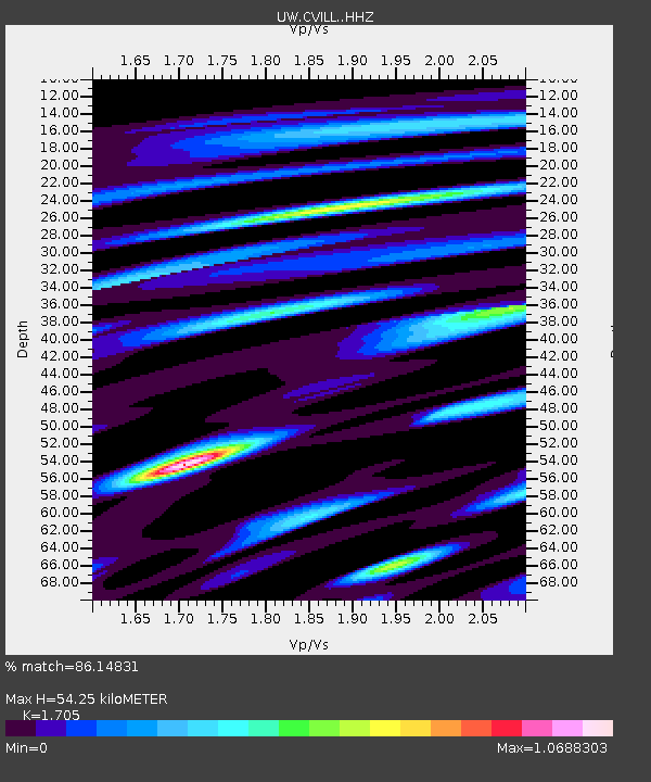
| Estimated Moho Depth: |
54.25 km |
| Estimated Crust Vp/Vs: |
1.71 |
| Assumed Crust Vp: |
6.571 km/s |
| Estimated Crust Vs: |
3.854 km/s |
| Estimated Crust Poisson's Ratio: |
0.24 |
|
| Radial Match: |
86.14831 % |
| Radial Bump: |
400 |
| Transverse Match: |
56.08399 % |
| Transverse Bump: |
400 |
| SOD ConfigId: |
31937991 |
| Insert Time: |
2023-11-09 16:37:23.881 +0000 |
| GWidth: |
2.5 |
| Max Bumps: |
400 |
| Tol: |
0.001 |
|

Signal To Noise
| Channel | StoN | STA | LTA |
| UW:CVILL: :HHZ:20231026T16:13:01.659992Z | 4.6534176 | 5.319187E-7 | 1.143071E-7 |
| UW:CVILL: :HHN:20231026T16:13:01.659992Z | 2.4902446 | 3.6735867E-7 | 1.4751912E-7 |
| UW:CVILL: :HHE:20231026T16:13:01.659992Z | 2.1696012 | 2.910639E-7 | 1.3415548E-7 |
| Arrivals |
| Ps | 6.2 SECOND |
| PpPs | 21 SECOND |
| PsPs/PpSs | 27 SECOND |


