You are here: Home > Network List > UW - Pacific Northwest Regional Seismic Network Stations List
> Station DY2 Dyer Hill 2, WA, USA > Earthquake Result Viewer
DY2 Dyer Hill 2, WA, USA - Earthquake Result Viewer
| Earthquake location: |
Komandorskiye Ostrova Region |
| Earthquake latitude/longitude: |
56.1/164.7 |
| Earthquake time(UTC): |
2023/10/26 (299) 16:05:11 GMT |
| Earthquake Depth: |
2.4 km |
| Earthquake Magnitude: |
5.9 Mww |
| Earthquake Catalog/Contributor: |
NEIC PDE/us |
|
| Network: |
UW Pacific Northwest Regional Seismic Network |
| Station: |
DY2 Dyer Hill 2, WA, USA |
| Lat/Lon: |
47.99 N/119.77 W |
| Elevation: |
892 m |
|
| Distance: |
45.0 deg |
| Az: |
66.996 deg |
| Baz: |
309.768 deg |
| Ray Param: |
0.071618475 |
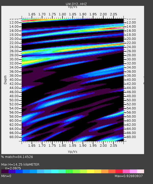
| Estimated Moho Depth: |
14.25 km |
| Estimated Crust Vp/Vs: |
2.10 |
| Assumed Crust Vp: |
6.419 km/s |
| Estimated Crust Vs: |
3.06 km/s |
| Estimated Crust Poisson's Ratio: |
0.35 |
|
| Radial Match: |
84.14526 % |
| Radial Bump: |
400 |
| Transverse Match: |
68.49789 % |
| Transverse Bump: |
400 |
| SOD ConfigId: |
31937991 |
| Insert Time: |
2023-11-09 16:37:39.131 +0000 |
| GWidth: |
2.5 |
| Max Bumps: |
400 |
| Tol: |
0.001 |
|

Signal To Noise
| Channel | StoN | STA | LTA |
| UW:DY2: :HHZ:20231026T16:12:56.830005Z | 6.208635 | 6.681231E-7 | 1.0761192E-7 |
| UW:DY2: :HHN:20231026T16:12:56.830005Z | 2.0494225 | 1.885093E-7 | 9.198167E-8 |
| UW:DY2: :HHE:20231026T16:12:56.830005Z | 3.2486703 | 2.6587776E-7 | 8.184202E-8 |
| Arrivals |
| Ps | 2.6 SECOND |
| PpPs | 6.5 SECOND |
| PsPs/PpSs | 9.1 SECOND |


