You are here: Home > Network List > UW - Pacific Northwest Regional Seismic Network Stations List
> Station ETW Entiat, WA, USA > Earthquake Result Viewer
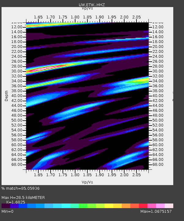
ETW Entiat, WA, USA - Earthquake Result Viewer
| Earthquake location: |
Komandorskiye Ostrova Region |
| Earthquake latitude/longitude: |
56.1/164.7 |
| Earthquake time(UTC): |
2023/10/26 (299) 16:05:11 GMT |
| Earthquake Depth: |
2.4 km |
| Earthquake Magnitude: |
5.9 Mww |
| Earthquake Catalog/Contributor: |
NEIC PDE/us |
|
| Network: |
UW Pacific Northwest Regional Seismic Network |
| Station: |
ETW Entiat, WA, USA |
| Lat/Lon: |
47.60 N/120.33 W |
| Elevation: |
1469 m |
|
| Distance: |
44.9 deg |
| Az: |
67.752 deg |
| Baz: |
309.89 deg |
| Ray Param: |
0.07164883 |
| Estimated Moho Depth: |
28.5 km |
| Estimated Crust Vp/Vs: |
1.68 |
| Assumed Crust Vp: |
6.597 km/s |
| Estimated Crust Vs: |
3.921 km/s |
| Estimated Crust Poisson's Ratio: |
0.23 |
|
| Radial Match: |
85.05936 % |
| Radial Bump: |
400 |
| Transverse Match: |
62.27583 % |
| Transverse Bump: |
400 |
| SOD ConfigId: |
31937991 |
| Insert Time: |
2023-11-09 16:37:45.902 +0000 |
| GWidth: |
2.5 |
| Max Bumps: |
400 |
| Tol: |
0.001 |
|

Signal To Noise
| Channel | StoN | STA | LTA |
| UW:ETW: :HHZ:20231026T16:12:56.46001Z | 4.679349 | 6.657823E-7 | 1.4228097E-7 |
| UW:ETW: :HHN:20231026T16:12:56.46001Z | 1.6711447 | 2.0616389E-7 | 1.2336687E-7 |
| UW:ETW: :HHE:20231026T16:12:56.46001Z | 2.5525365 | 2.7151054E-7 | 1.06368915E-7 |
| Arrivals |
| Ps | 3.2 SECOND |
| PpPs | 11 SECOND |
| PsPs/PpSs | 14 SECOND |


