You are here: Home > Network List > TA - USArray Transportable Network (new EarthScope stations) Stations List
> Station E23A Ismay, MT, USA > Earthquake Result Viewer
E23A Ismay, MT, USA - Earthquake Result Viewer
| Earthquake location: |
Off East Coast Of Kamchatka |
| Earthquake latitude/longitude: |
52.5/159.8 |
| Earthquake time(UTC): |
2010/07/30 (211) 03:56:13 GMT |
| Earthquake Depth: |
23 km |
| Earthquake Magnitude: |
6.1 MB, 6.3 MS, 6.3 MW, 6.3 MW |
| Earthquake Catalog/Contributor: |
WHDF/NEIC |
|
| Network: |
TA USArray Transportable Network (new EarthScope stations) |
| Station: |
E23A Ismay, MT, USA |
| Lat/Lon: |
46.50 N/105.31 W |
| Elevation: |
750 m |
|
| Distance: |
57.6 deg |
| Az: |
54.651 deg |
| Baz: |
313.794 deg |
| Ray Param: |
0.06338436 |
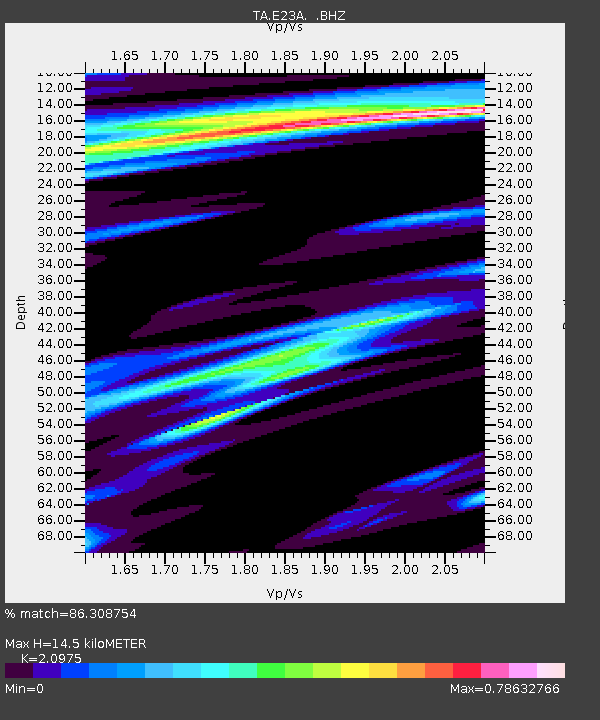
| Estimated Moho Depth: |
14.5 km |
| Estimated Crust Vp/Vs: |
2.10 |
| Assumed Crust Vp: |
6.438 km/s |
| Estimated Crust Vs: |
3.069 km/s |
| Estimated Crust Poisson's Ratio: |
0.35 |
|
| Radial Match: |
86.308754 % |
| Radial Bump: |
345 |
| Transverse Match: |
72.72533 % |
| Transverse Bump: |
349 |
| SOD ConfigId: |
319893 |
| Insert Time: |
2011-01-05 14:33:22.935 +0000 |
| GWidth: |
2.5 |
| Max Bumps: |
400 |
| Tol: |
0.001 |
|
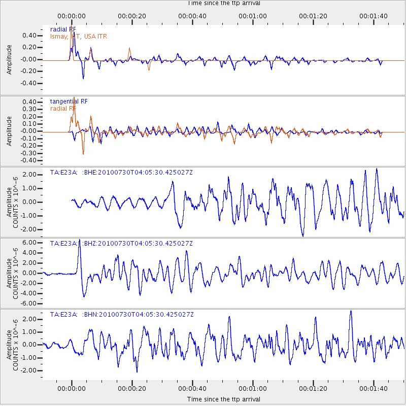
Signal To Noise
| Channel | StoN | STA | LTA |
| TA:E23A: :BHZ:20100730T04:05:30.425027Z | 11.666548 | 2.9059686E-6 | 2.4908556E-7 |
| TA:E23A: :BHN:20100730T04:05:30.425027Z | 1.6357949 | 4.817516E-7 | 2.9450615E-7 |
| TA:E23A: :BHE:20100730T04:05:30.425027Z | 2.8058622 | 6.9558195E-7 | 2.479031E-7 |
| Arrivals |
| Ps | 2.6 SECOND |
| PpPs | 6.7 SECOND |
| PsPs/PpSs | 9.3 SECOND |


