You are here: Home > Network List > TA - USArray Transportable Network (new EarthScope stations) Stations List
> Station K25A Mack Ranch, Harrison, NE, USA > Earthquake Result Viewer
K25A Mack Ranch, Harrison, NE, USA - Earthquake Result Viewer
| Earthquake location: |
Off East Coast Of Kamchatka |
| Earthquake latitude/longitude: |
52.5/159.8 |
| Earthquake time(UTC): |
2010/07/30 (211) 03:56:13 GMT |
| Earthquake Depth: |
23 km |
| Earthquake Magnitude: |
6.1 MB, 6.3 MS, 6.3 MW, 6.3 MW |
| Earthquake Catalog/Contributor: |
WHDF/NEIC |
|
| Network: |
TA USArray Transportable Network (new EarthScope stations) |
| Station: |
K25A Mack Ranch, Harrison, NE, USA |
| Lat/Lon: |
42.61 N/103.87 W |
| Elevation: |
1437 m |
|
| Distance: |
61.0 deg |
| Az: |
57.008 deg |
| Baz: |
316.003 deg |
| Ray Param: |
0.061112575 |
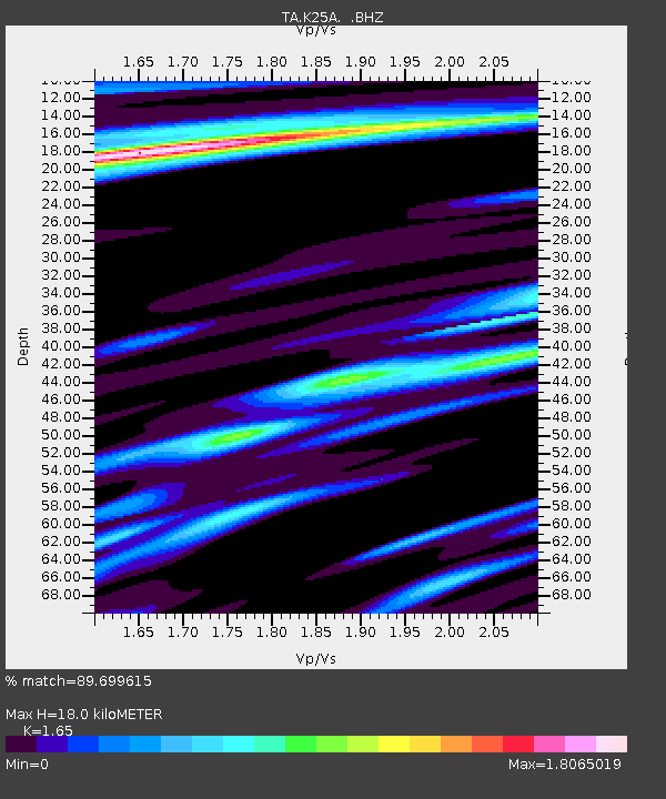
| Estimated Moho Depth: |
18.0 km |
| Estimated Crust Vp/Vs: |
1.65 |
| Assumed Crust Vp: |
6.483 km/s |
| Estimated Crust Vs: |
3.929 km/s |
| Estimated Crust Poisson's Ratio: |
0.21 |
|
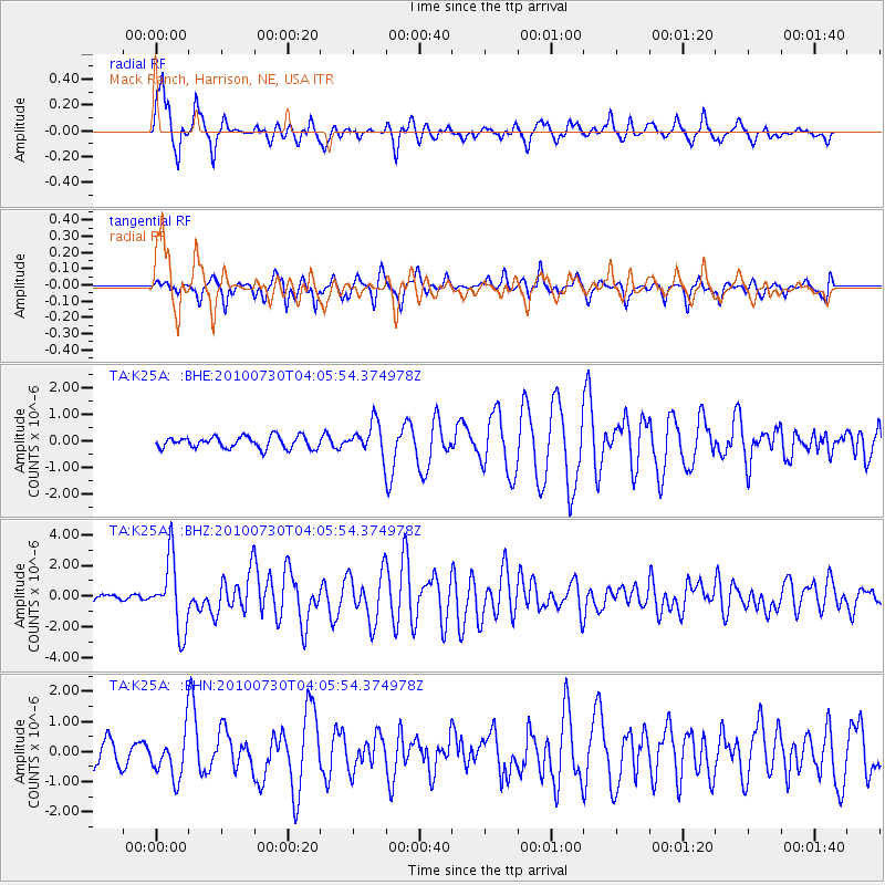
| Radial Match: |
89.699615 % |
| Radial Bump: |
400 |
| Transverse Match: |
81.63665 % |
| Transverse Bump: |
400 |
| SOD ConfigId: |
319893 |
| Insert Time: |
2011-01-05 14:33:37.098 +0000 |
| GWidth: |
2.5 |
| Max Bumps: |
400 |
| Tol: |
0.001 |
|
Signal To Noise
| Channel | StoN | STA | LTA |
| TA:K25A: :BHZ:20100730T04:05:54.374978Z | 18.970036 | 2.262162E-6 | 1.1924924E-7 |
| TA:K25A: :BHN:20100730T04:05:54.374978Z | 2.174597 | 7.4110136E-7 | 3.407994E-7 |
| TA:K25A: :BHE:20100730T04:05:54.374978Z | 2.665873 | 5.9828704E-7 | 2.2442443E-7 |
| Arrivals |
| Ps | 1.9 SECOND |
| PpPs | 7.0 SECOND |
| PsPs/PpSs | 8.9 SECOND |


