You are here: Home > Network List > YX16 - Raton Basin UNM Broadband Network Stations List
> Station UNM5 Southernmost CO Station > Earthquake Result Viewer
UNM5 Southernmost CO Station - Earthquake Result Viewer
| Earthquake location: |
Komandorskiye Ostrova Region |
| Earthquake latitude/longitude: |
56.1/164.7 |
| Earthquake time(UTC): |
2023/10/26 (299) 16:05:11 GMT |
| Earthquake Depth: |
2.4 km |
| Earthquake Magnitude: |
5.9 Mww |
| Earthquake Catalog/Contributor: |
NEIC PDE/us |
|
| Network: |
YX Raton Basin UNM Broadband Network |
| Station: |
UNM5 Southernmost CO Station |
| Lat/Lon: |
37.12 N/104.78 W |
| Elevation: |
2035 m |
|
| Distance: |
60.4 deg |
| Az: |
66.801 deg |
| Baz: |
319.827 deg |
| Ray Param: |
0.061578438 |
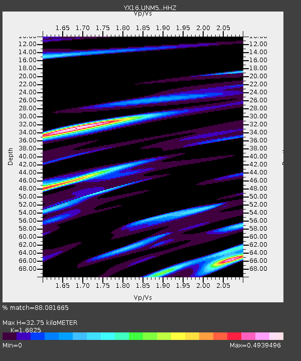
| Estimated Moho Depth: |
32.75 km |
| Estimated Crust Vp/Vs: |
1.68 |
| Assumed Crust Vp: |
6.316 km/s |
| Estimated Crust Vs: |
3.754 km/s |
| Estimated Crust Poisson's Ratio: |
0.23 |
|
| Radial Match: |
88.081665 % |
| Radial Bump: |
329 |
| Transverse Match: |
73.32228 % |
| Transverse Bump: |
400 |
| SOD ConfigId: |
31937991 |
| Insert Time: |
2023-11-09 16:41:24.626 +0000 |
| GWidth: |
2.5 |
| Max Bumps: |
400 |
| Tol: |
0.001 |
|

Signal To Noise
| Channel | StoN | STA | LTA |
| YX:UNM5: :HHZ:20231026T16:14:51.020008Z | 2.9880462 | 2.4763196E-7 | 8.28742E-8 |
| YX:UNM5: :HHN:20231026T16:14:51.020008Z | 1.269794 | 1.2331112E-7 | 9.711113E-8 |
| YX:UNM5: :HHE:20231026T16:14:51.020008Z | 0.9878991 | 8.238081E-8 | 8.33899E-8 |
| Arrivals |
| Ps | 3.7 SECOND |
| PpPs | 13 SECOND |
| PsPs/PpSs | 17 SECOND |


