You are here: Home > Network List > TA - USArray Transportable Network (new EarthScope stations) Stations List
> Station F23A Volborg, MT, USA > Earthquake Result Viewer
F23A Volborg, MT, USA - Earthquake Result Viewer

| Earthquake location: |
Off East Coast Of Kamchatka |
| Earthquake latitude/longitude: |
52.5/159.8 |
| Earthquake time(UTC): |
2010/07/30 (211) 03:56:13 GMT |
| Earthquake Depth: |
23 km |
| Earthquake Magnitude: |
6.1 MB, 6.3 MS, 6.3 MW, 6.3 MW |
| Earthquake Catalog/Contributor: |
WHDF/NEIC |
|
| Network: |
TA USArray Transportable Network (new EarthScope stations) |
| Station: |
F23A Volborg, MT, USA |
| Lat/Lon: |
45.72 N/105.41 W |
| Elevation: |
953 m |
|
| Distance: |
58.0 deg |
| Az: |
55.368 deg |
| Baz: |
314.105 deg |
| Ray Param: |
0.063068695 |
| Estimated Moho Depth: |
34.75 km |
| Estimated Crust Vp/Vs: |
2.04 |
| Assumed Crust Vp: |
6.242 km/s |
| Estimated Crust Vs: |
3.06 km/s |
| Estimated Crust Poisson's Ratio: |
0.34 |
|
| Radial Match: |
91.03356 % |
| Radial Bump: |
315 |
| Transverse Match: |
82.752144 % |
| Transverse Bump: |
323 |
| SOD ConfigId: |
319893 |
| Insert Time: |
2011-01-05 14:34:07.780 +0000 |
| GWidth: |
2.5 |
| Max Bumps: |
400 |
| Tol: |
0.001 |
|
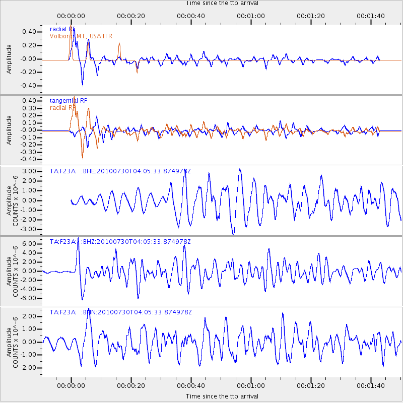
Signal To Noise
| Channel | StoN | STA | LTA |
| TA:F23A: :BHZ:20100730T04:05:33.874978Z | 15.697175 | 3.442891E-6 | 2.1933188E-7 |
| TA:F23A: :BHN:20100730T04:05:33.874978Z | 1.9834381 | 7.025137E-7 | 3.5418986E-7 |
| TA:F23A: :BHE:20100730T04:05:33.874978Z | 1.2517245 | 7.887293E-7 | 6.301142E-7 |
| Arrivals |
| Ps | 6.0 SECOND |
| PpPs | 16 SECOND |
| PsPs/PpSs | 22 SECOND |


