You are here: Home > Network List > TA - USArray Transportable Network (new EarthScope stations) Stations List
> Station N26A Koester Ranch, Padroni, CO, USA > Earthquake Result Viewer
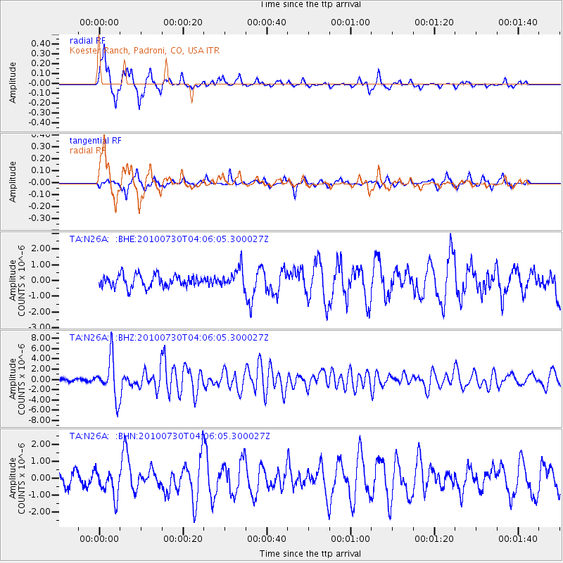
N26A Koester Ranch, Padroni, CO, USA - Earthquake Result Viewer
*The percent match for this event was below the threshold and hence no stack was calculated.
| Earthquake location: |
Off East Coast Of Kamchatka |
| Earthquake latitude/longitude: |
52.5/159.8 |
| Earthquake time(UTC): |
2010/07/30 (211) 03:56:13 GMT |
| Earthquake Depth: |
23 km |
| Earthquake Magnitude: |
6.1 MB, 6.3 MS, 6.3 MW, 6.3 MW |
| Earthquake Catalog/Contributor: |
WHDF/NEIC |
|
| Network: |
TA USArray Transportable Network (new EarthScope stations) |
| Station: |
N26A Koester Ranch, Padroni, CO, USA |
| Lat/Lon: |
40.83 N/103.22 W |
| Elevation: |
1284 m |
|
| Distance: |
62.7 deg |
| Az: |
58.001 deg |
| Baz: |
316.902 deg |
| Ray Param: |
$rayparam |
*The percent match for this event was below the threshold and hence was not used in the summary stack. |
|
| Radial Match: |
83.20212 % |
| Radial Bump: |
284 |
| Transverse Match: |
66.2039 % |
| Transverse Bump: |
311 |
| SOD ConfigId: |
319893 |
| Insert Time: |
2011-01-05 14:35:04.874 +0000 |
| GWidth: |
2.5 |
| Max Bumps: |
400 |
| Tol: |
0.001 |
|
Signal To Noise
| Channel | StoN | STA | LTA |
| TA:N26A: :BHZ:20100730T04:06:05.300027Z | 15.598239 | 3.915957E-6 | 2.5105126E-7 |
| TA:N26A: :BHN:20100730T04:06:05.300027Z | 1.992747 | 8.1116366E-7 | 4.0705802E-7 |
| TA:N26A: :BHE:20100730T04:06:05.300027Z | 1.6971327 | 6.4179585E-7 | 3.7816483E-7 |
| Arrivals |
| Ps | |
| PpPs | |
| PsPs/PpSs | |


