You are here: Home > Network List > CI - Caltech Regional Seismic Network Stations List
> Station MPP McPhearson Peak > Earthquake Result Viewer
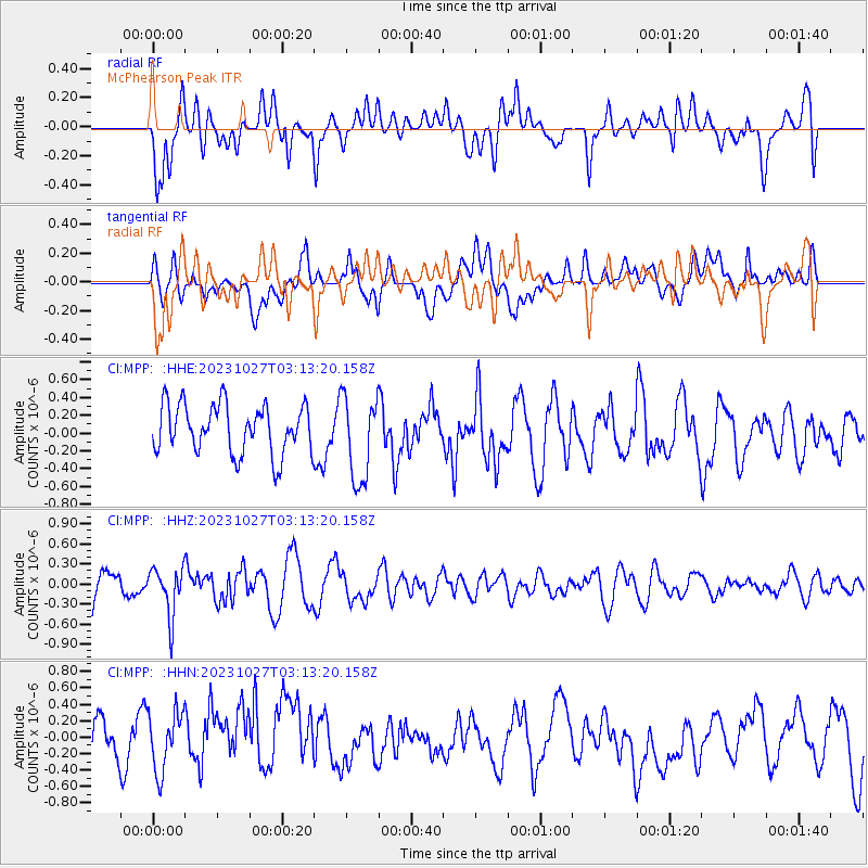
MPP McPhearson Peak - Earthquake Result Viewer
*The percent match for this event was below the threshold and hence no stack was calculated.
| Earthquake location: |
Tonga Islands |
| Earthquake latitude/longitude: |
-17.6/-173.8 |
| Earthquake time(UTC): |
2023/10/27 (300) 03:02:24 GMT |
| Earthquake Depth: |
35 km |
| Earthquake Magnitude: |
5.6 mb |
| Earthquake Catalog/Contributor: |
NEIC PDE/us |
|
| Network: |
CI Caltech Regional Seismic Network |
| Station: |
MPP McPhearson Peak |
| Lat/Lon: |
34.89 N/119.81 W |
| Elevation: |
1739 m |
|
| Distance: |
73.1 deg |
| Az: |
43.998 deg |
| Baz: |
233.706 deg |
| Ray Param: |
$rayparam |
*The percent match for this event was below the threshold and hence was not used in the summary stack. |
|
| Radial Match: |
60.307087 % |
| Radial Bump: |
400 |
| Transverse Match: |
56.801773 % |
| Transverse Bump: |
400 |
| SOD ConfigId: |
31937991 |
| Insert Time: |
2023-11-10 03:13:59.843 +0000 |
| GWidth: |
2.5 |
| Max Bumps: |
400 |
| Tol: |
0.001 |
|
Signal To Noise
| Channel | StoN | STA | LTA |
| CI:MPP: :HHZ:20231027T03:13:20.158Z | 1.0077548 | 3.6090387E-7 | 3.5812667E-7 |
| CI:MPP: :HHN:20231027T03:13:20.158Z | 1.169422 | 3.8492652E-7 | 3.2915963E-7 |
| CI:MPP: :HHE:20231027T03:13:20.158Z | 1.7689816 | 4.852087E-7 | 2.7428706E-7 |
| Arrivals |
| Ps | |
| PpPs | |
| PsPs/PpSs | |


