You are here: Home > Network List > TA - USArray Transportable Network (new EarthScope stations) Stations List
> Station 530A J-C Ranch, Comstock, TX, USA > Earthquake Result Viewer
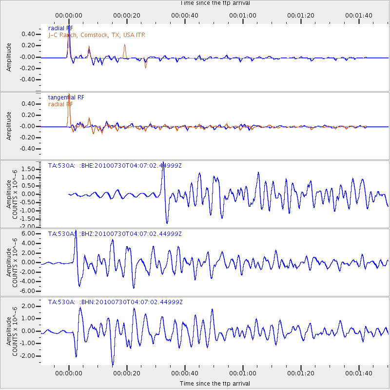
530A J-C Ranch, Comstock, TX, USA - Earthquake Result Viewer
| Earthquake location: |
Off East Coast Of Kamchatka |
| Earthquake latitude/longitude: |
52.5/159.8 |
| Earthquake time(UTC): |
2010/07/30 (211) 03:56:13 GMT |
| Earthquake Depth: |
23 km |
| Earthquake Magnitude: |
6.1 MB, 6.3 MS, 6.3 MW, 6.3 MW |
| Earthquake Catalog/Contributor: |
WHDF/NEIC |
|
| Network: |
TA USArray Transportable Network (new EarthScope stations) |
| Station: |
530A J-C Ranch, Comstock, TX, USA |
| Lat/Lon: |
30.15 N/101.34 W |
| Elevation: |
636 m |
|
| Distance: |
71.7 deg |
| Az: |
64.372 deg |
| Baz: |
320.478 deg |
| Ray Param: |
0.054137662 |
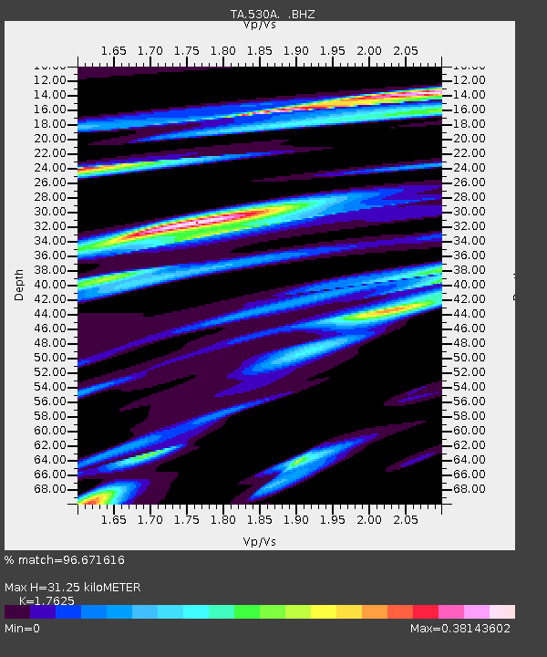
| Estimated Moho Depth: |
31.25 km |
| Estimated Crust Vp/Vs: |
1.76 |
| Assumed Crust Vp: |
6.38 km/s |
| Estimated Crust Vs: |
3.62 km/s |
| Estimated Crust Poisson's Ratio: |
0.26 |
|
| Radial Match: |
96.671616 % |
| Radial Bump: |
244 |
| Transverse Match: |
92.24256 % |
| Transverse Bump: |
343 |
| SOD ConfigId: |
319893 |
| Insert Time: |
2011-01-05 14:37:38.846 +0000 |
| GWidth: |
2.5 |
| Max Bumps: |
400 |
| Tol: |
0.001 |
|
Signal To Noise
| Channel | StoN | STA | LTA |
| TA:530A: :BHZ:20100730T04:07:02.44999Z | 18.584932 | 2.9769017E-6 | 1.6017823E-7 |
| TA:530A: :BHN:20100730T04:07:02.44999Z | 16.028002 | 1.0318896E-6 | 6.438043E-8 |
| TA:530A: :BHE:20100730T04:07:02.44999Z | 8.254256 | 9.2441593E-7 | 1.1199263E-7 |
| Arrivals |
| Ps | 3.9 SECOND |
| PpPs | 13 SECOND |
| PsPs/PpSs | 17 SECOND |


