You are here: Home > Network List > IW - Intermountain West Stations List
> Station DLMT Dillon, Montana, USA > Earthquake Result Viewer
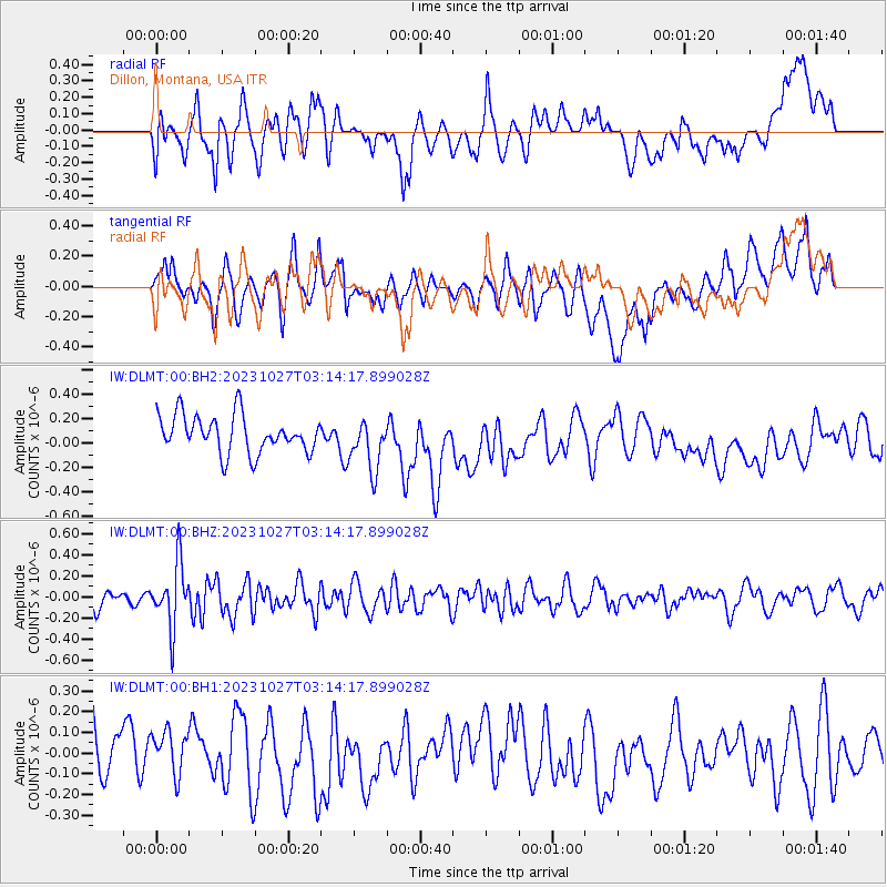
DLMT Dillon, Montana, USA - Earthquake Result Viewer
*The percent match for this event was below the threshold and hence no stack was calculated.
| Earthquake location: |
Tonga Islands |
| Earthquake latitude/longitude: |
-17.6/-173.8 |
| Earthquake time(UTC): |
2023/10/27 (300) 03:02:24 GMT |
| Earthquake Depth: |
35 km |
| Earthquake Magnitude: |
5.6 mb |
| Earthquake Catalog/Contributor: |
NEIC PDE/us |
|
| Network: |
IW Intermountain West |
| Station: |
DLMT Dillon, Montana, USA |
| Lat/Lon: |
45.36 N/112.60 W |
| Elevation: |
1569 m |
|
| Distance: |
83.6 deg |
| Az: |
38.426 deg |
| Baz: |
237.233 deg |
| Ray Param: |
$rayparam |
*The percent match for this event was below the threshold and hence was not used in the summary stack. |
|
| Radial Match: |
41.680202 % |
| Radial Bump: |
400 |
| Transverse Match: |
46.26742 % |
| Transverse Bump: |
400 |
| SOD ConfigId: |
31937991 |
| Insert Time: |
2023-11-10 03:17:52.255 +0000 |
| GWidth: |
2.5 |
| Max Bumps: |
400 |
| Tol: |
0.001 |
|
Signal To Noise
| Channel | StoN | STA | LTA |
| IW:DLMT:00:BHZ:20231027T03:14:17.899028Z | 4.8676257 | 2.9876298E-7 | 6.1377555E-8 |
| IW:DLMT:00:BH1:20231027T03:14:17.899028Z | 0.7875031 | 1.1168807E-7 | 1.4182555E-7 |
| IW:DLMT:00:BH2:20231027T03:14:17.899028Z | 1.4094542 | 2.1354643E-7 | 1.5151001E-7 |
| Arrivals |
| Ps | |
| PpPs | |
| PsPs/PpSs | |


