You are here: Home > Network List > TA - USArray Transportable Network (new EarthScope stations) Stations List
> Station Z32A Haskell, TX, USA > Earthquake Result Viewer
Z32A Haskell, TX, USA - Earthquake Result Viewer
| Earthquake location: |
Off East Coast Of Kamchatka |
| Earthquake latitude/longitude: |
52.5/159.8 |
| Earthquake time(UTC): |
2010/07/30 (211) 03:56:13 GMT |
| Earthquake Depth: |
23 km |
| Earthquake Magnitude: |
6.1 MB, 6.3 MS, 6.3 MW, 6.3 MW |
| Earthquake Catalog/Contributor: |
WHDF/NEIC |
|
| Network: |
TA USArray Transportable Network (new EarthScope stations) |
| Station: |
Z32A Haskell, TX, USA |
| Lat/Lon: |
33.31 N/99.48 W |
| Elevation: |
427 m |
|
| Distance: |
70.3 deg |
| Az: |
60.959 deg |
| Baz: |
320.338 deg |
| Ray Param: |
0.055069335 |
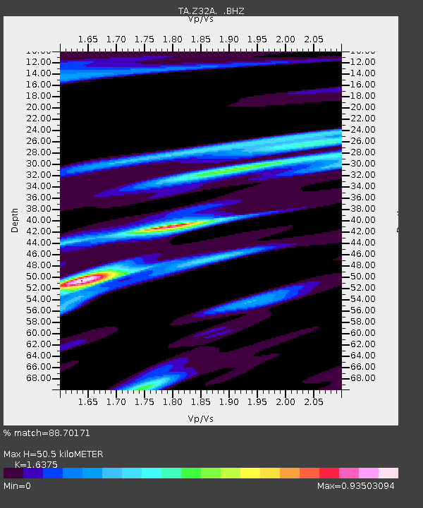
| Estimated Moho Depth: |
50.5 km |
| Estimated Crust Vp/Vs: |
1.64 |
| Assumed Crust Vp: |
6.426 km/s |
| Estimated Crust Vs: |
3.924 km/s |
| Estimated Crust Poisson's Ratio: |
0.20 |
|
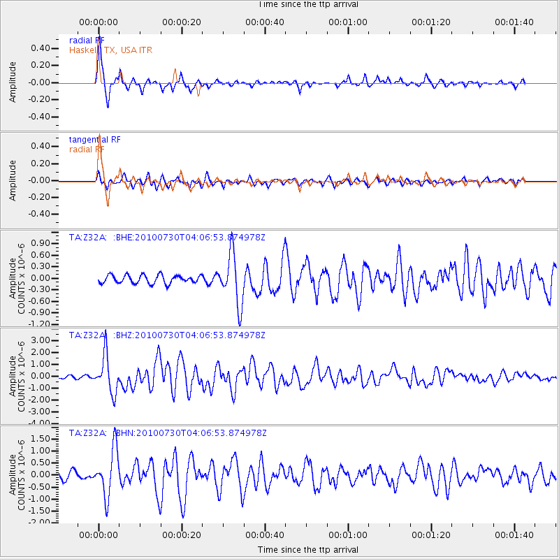
| Radial Match: |
88.70171 % |
| Radial Bump: |
349 |
| Transverse Match: |
80.43199 % |
| Transverse Bump: |
378 |
| SOD ConfigId: |
319893 |
| Insert Time: |
2011-01-05 14:38:14.368 +0000 |
| GWidth: |
2.5 |
| Max Bumps: |
400 |
| Tol: |
0.001 |
|
Signal To Noise
| Channel | StoN | STA | LTA |
| TA:Z32A: :BHZ:20100730T04:06:53.874978Z | 12.600007 | 1.6222561E-6 | 1.2875041E-7 |
| TA:Z32A: :BHN:20100730T04:06:53.874978Z | 6.3912873 | 1.0009638E-6 | 1.5661381E-7 |
| TA:Z32A: :BHE:20100730T04:06:53.874978Z | 6.401919 | 6.813139E-7 | 1.06423386E-7 |
| Arrivals |
| Ps | 5.2 SECOND |
| PpPs | 20 SECOND |
| PsPs/PpSs | 25 SECOND |


