You are here: Home > Network List > TA - USArray Transportable Network (new EarthScope stations) Stations List
> Station Y31A Rekieta Farm, Paducah, TX, USA > Earthquake Result Viewer
Y31A Rekieta Farm, Paducah, TX, USA - Earthquake Result Viewer
| Earthquake location: |
Off East Coast Of Kamchatka |
| Earthquake latitude/longitude: |
52.5/159.8 |
| Earthquake time(UTC): |
2010/07/30 (211) 03:56:13 GMT |
| Earthquake Depth: |
23 km |
| Earthquake Magnitude: |
6.1 MB, 6.3 MS, 6.3 MW, 6.3 MW |
| Earthquake Catalog/Contributor: |
WHDF/NEIC |
|
| Network: |
TA USArray Transportable Network (new EarthScope stations) |
| Station: |
Y31A Rekieta Farm, Paducah, TX, USA |
| Lat/Lon: |
33.96 N/100.26 W |
| Elevation: |
530 m |
|
| Distance: |
69.3 deg |
| Az: |
61.046 deg |
| Baz: |
319.937 deg |
| Ray Param: |
0.05568128 |
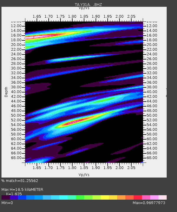
| Estimated Moho Depth: |
16.5 km |
| Estimated Crust Vp/Vs: |
1.63 |
| Assumed Crust Vp: |
6.426 km/s |
| Estimated Crust Vs: |
3.93 km/s |
| Estimated Crust Poisson's Ratio: |
0.20 |
|
| Radial Match: |
81.25562 % |
| Radial Bump: |
400 |
| Transverse Match: |
73.71105 % |
| Transverse Bump: |
400 |
| SOD ConfigId: |
319893 |
| Insert Time: |
2011-01-05 14:38:51.214 +0000 |
| GWidth: |
2.5 |
| Max Bumps: |
400 |
| Tol: |
0.001 |
|

Signal To Noise
| Channel | StoN | STA | LTA |
| TA:Y31A: :BHZ:20100730T04:06:48.225015Z | 15.997667 | 1.7102718E-6 | 1.0690757E-7 |
| TA:Y31A: :BHN:20100730T04:06:48.225015Z | 2.5726745 | 6.4653346E-7 | 2.513079E-7 |
| TA:Y31A: :BHE:20100730T04:06:48.225015Z | 5.1720953 | 5.147193E-7 | 9.951853E-8 |
| Arrivals |
| Ps | 1.7 SECOND |
| PpPs | 6.5 SECOND |
| PsPs/PpSs | 8.2 SECOND |


