You are here: Home > Network List > TA - USArray Transportable Network (new EarthScope stations) Stations List
> Station W31A Holland Ranch, Erick, OK, USA > Earthquake Result Viewer
W31A Holland Ranch, Erick, OK, USA - Earthquake Result Viewer

| Earthquake location: |
Off East Coast Of Kamchatka |
| Earthquake latitude/longitude: |
52.5/159.8 |
| Earthquake time(UTC): |
2010/07/30 (211) 03:56:13 GMT |
| Earthquake Depth: |
23 km |
| Earthquake Magnitude: |
6.1 MB, 6.3 MS, 6.3 MW, 6.3 MW |
| Earthquake Catalog/Contributor: |
WHDF/NEIC |
|
| Network: |
TA USArray Transportable Network (new EarthScope stations) |
| Station: |
W31A Holland Ranch, Erick, OK, USA |
| Lat/Lon: |
35.19 N/99.94 W |
| Elevation: |
644 m |
|
| Distance: |
68.6 deg |
| Az: |
59.988 deg |
| Baz: |
319.736 deg |
| Ray Param: |
0.05618218 |
| Estimated Moho Depth: |
10.75 km |
| Estimated Crust Vp/Vs: |
1.61 |
| Assumed Crust Vp: |
6.315 km/s |
| Estimated Crust Vs: |
3.922 km/s |
| Estimated Crust Poisson's Ratio: |
0.19 |
|
| Radial Match: |
92.66326 % |
| Radial Bump: |
286 |
| Transverse Match: |
86.21598 % |
| Transverse Bump: |
400 |
| SOD ConfigId: |
319893 |
| Insert Time: |
2011-01-05 14:39:10.139 +0000 |
| GWidth: |
2.5 |
| Max Bumps: |
400 |
| Tol: |
0.001 |
|
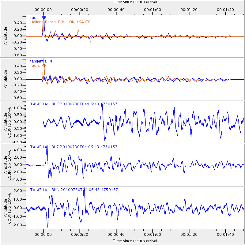
Signal To Noise
| Channel | StoN | STA | LTA |
| TA:W31A: :BHZ:20100730T04:06:43.475015Z | 17.756084 | 2.2655454E-6 | 1.2759263E-7 |
| TA:W31A: :BHN:20100730T04:06:43.475015Z | 4.5723596 | 9.64352E-7 | 2.1090905E-7 |
| TA:W31A: :BHE:20100730T04:06:43.475015Z | 3.548336 | 7.401089E-7 | 2.0857914E-7 |
| Arrivals |
| Ps | 1.1 SECOND |
| PpPs | 4.3 SECOND |
| PsPs/PpSs | 5.3 SECOND |


