You are here: Home > Network List > TA - USArray Transportable Network (new EarthScope stations) Stations List
> Station R28A Tribune, KS, USA > Earthquake Result Viewer
R28A Tribune, KS, USA - Earthquake Result Viewer
| Earthquake location: |
Off East Coast Of Kamchatka |
| Earthquake latitude/longitude: |
52.5/159.8 |
| Earthquake time(UTC): |
2010/07/30 (211) 03:56:13 GMT |
| Earthquake Depth: |
23 km |
| Earthquake Magnitude: |
6.1 MB, 6.3 MS, 6.3 MW, 6.3 MW |
| Earthquake Catalog/Contributor: |
WHDF/NEIC |
|
| Network: |
TA USArray Transportable Network (new EarthScope stations) |
| Station: |
R28A Tribune, KS, USA |
| Lat/Lon: |
38.34 N/101.81 W |
| Elevation: |
1108 m |
|
| Distance: |
65.2 deg |
| Az: |
58.97 deg |
| Baz: |
318.224 deg |
| Ray Param: |
0.05838528 |
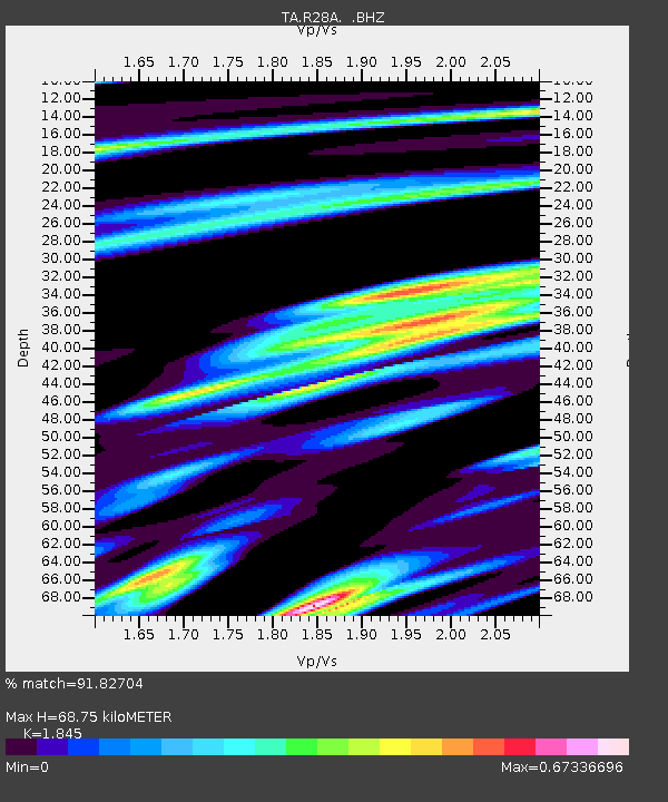
| Estimated Moho Depth: |
68.75 km |
| Estimated Crust Vp/Vs: |
1.85 |
| Assumed Crust Vp: |
6.483 km/s |
| Estimated Crust Vs: |
3.514 km/s |
| Estimated Crust Poisson's Ratio: |
0.29 |
|
| Radial Match: |
91.82704 % |
| Radial Bump: |
310 |
| Transverse Match: |
77.22277 % |
| Transverse Bump: |
400 |
| SOD ConfigId: |
319893 |
| Insert Time: |
2011-01-05 14:40:09.284 +0000 |
| GWidth: |
2.5 |
| Max Bumps: |
400 |
| Tol: |
0.001 |
|
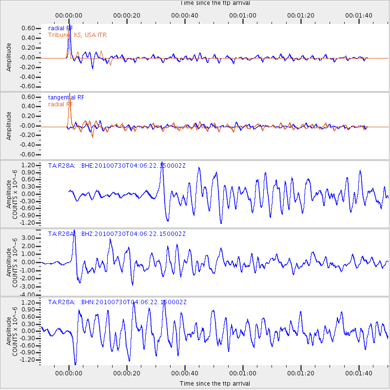
Signal To Noise
| Channel | StoN | STA | LTA |
| TA:R28A: :BHZ:20100730T04:06:22.150002Z | 18.346748 | 1.8133542E-6 | 9.883791E-8 |
| TA:R28A: :BHN:20100730T04:06:22.150002Z | 4.1300898 | 6.3799183E-7 | 1.5447408E-7 |
| TA:R28A: :BHE:20100730T04:06:22.150002Z | 7.3828 | 7.0351723E-7 | 9.5291384E-8 |
| Arrivals |
| Ps | 9.3 SECOND |
| PpPs | 29 SECOND |
| PsPs/PpSs | 38 SECOND |


