You are here: Home > Network List > US - United States National Seismic Network Stations List
> Station DUG Dugway, Tooele County, Utah, USA > Earthquake Result Viewer
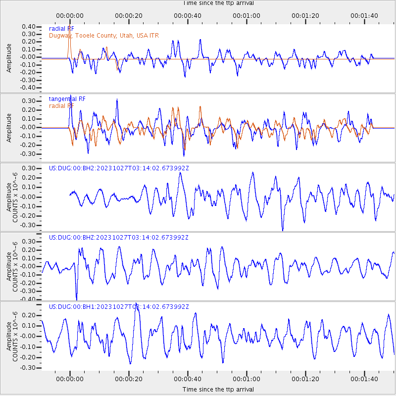
DUG Dugway, Tooele County, Utah, USA - Earthquake Result Viewer
*The percent match for this event was below the threshold and hence no stack was calculated.
| Earthquake location: |
Tonga Islands |
| Earthquake latitude/longitude: |
-17.6/-173.8 |
| Earthquake time(UTC): |
2023/10/27 (300) 03:02:24 GMT |
| Earthquake Depth: |
35 km |
| Earthquake Magnitude: |
5.6 mb |
| Earthquake Catalog/Contributor: |
NEIC PDE/us |
|
| Network: |
US United States National Seismic Network |
| Station: |
DUG Dugway, Tooele County, Utah, USA |
| Lat/Lon: |
40.19 N/112.81 W |
| Elevation: |
1477 m |
|
| Distance: |
80.7 deg |
| Az: |
42.733 deg |
| Baz: |
237.674 deg |
| Ray Param: |
$rayparam |
*The percent match for this event was below the threshold and hence was not used in the summary stack. |
|
| Radial Match: |
50.592194 % |
| Radial Bump: |
400 |
| Transverse Match: |
58.703987 % |
| Transverse Bump: |
400 |
| SOD ConfigId: |
31937991 |
| Insert Time: |
2023-11-10 03:28:00.282 +0000 |
| GWidth: |
2.5 |
| Max Bumps: |
400 |
| Tol: |
0.001 |
|
Signal To Noise
| Channel | StoN | STA | LTA |
| US:DUG:00:BHZ:20231027T03:14:02.673992Z | 2.2748878 | 1.57172E-7 | 6.909E-8 |
| US:DUG:00:BH1:20231027T03:14:02.673992Z | 1.2629294 | 1.0947845E-7 | 8.668612E-8 |
| US:DUG:00:BH2:20231027T03:14:02.673992Z | 1.5801082 | 6.958989E-8 | 4.4041222E-8 |
| Arrivals |
| Ps | |
| PpPs | |
| PsPs/PpSs | |


