You are here: Home > Network List > US - United States National Seismic Network Stations List
> Station MSO Missoula, Montana, USA > Earthquake Result Viewer
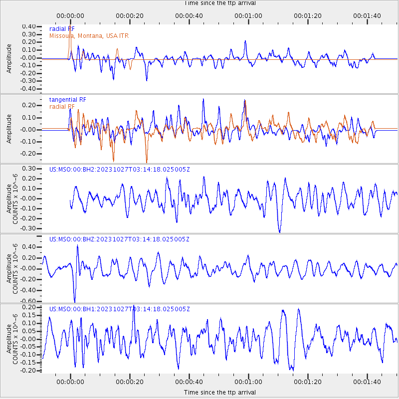
MSO Missoula, Montana, USA - Earthquake Result Viewer
*The percent match for this event was below the threshold and hence no stack was calculated.
| Earthquake location: |
Tonga Islands |
| Earthquake latitude/longitude: |
-17.6/-173.8 |
| Earthquake time(UTC): |
2023/10/27 (300) 03:02:24 GMT |
| Earthquake Depth: |
35 km |
| Earthquake Magnitude: |
5.6 mb |
| Earthquake Catalog/Contributor: |
NEIC PDE/us |
|
| Network: |
US United States National Seismic Network |
| Station: |
MSO Missoula, Montana, USA |
| Lat/Lon: |
46.83 N/113.94 W |
| Elevation: |
1264 m |
|
| Distance: |
83.6 deg |
| Az: |
36.675 deg |
| Baz: |
236.073 deg |
| Ray Param: |
$rayparam |
*The percent match for this event was below the threshold and hence was not used in the summary stack. |
|
| Radial Match: |
54.188705 % |
| Radial Bump: |
400 |
| Transverse Match: |
58.12906 % |
| Transverse Bump: |
400 |
| SOD ConfigId: |
31937991 |
| Insert Time: |
2023-11-10 03:28:18.623 +0000 |
| GWidth: |
2.5 |
| Max Bumps: |
400 |
| Tol: |
0.001 |
|
Signal To Noise
| Channel | StoN | STA | LTA |
| US:MSO:00:BHZ:20231027T03:14:18.025005Z | 2.894505 | 2.4096417E-7 | 8.324883E-8 |
| US:MSO:00:BH1:20231027T03:14:18.025005Z | 1.487395 | 9.559721E-8 | 6.427156E-8 |
| US:MSO:00:BH2:20231027T03:14:18.025005Z | 1.3969593 | 9.9338E-8 | 7.111016E-8 |
| Arrivals |
| Ps | |
| PpPs | |
| PsPs/PpSs | |


