You are here: Home > Network List > TA - USArray Transportable Network (new EarthScope stations) Stations List
> Station Q29A Oakley, KS, USA > Earthquake Result Viewer
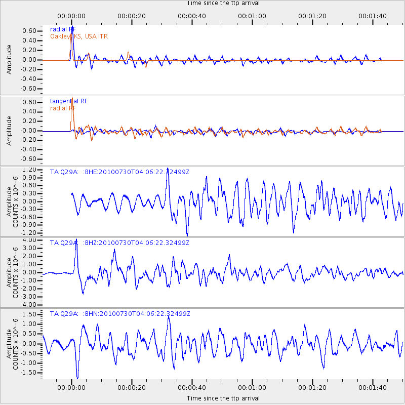
Q29A Oakley, KS, USA - Earthquake Result Viewer

| Earthquake location: |
Off East Coast Of Kamchatka |
| Earthquake latitude/longitude: |
52.5/159.8 |
| Earthquake time(UTC): |
2010/07/30 (211) 03:56:13 GMT |
| Earthquake Depth: |
23 km |
| Earthquake Magnitude: |
6.1 MB, 6.3 MS, 6.3 MW, 6.3 MW |
| Earthquake Catalog/Contributor: |
WHDF/NEIC |
|
| Network: |
TA USArray Transportable Network (new EarthScope stations) |
| Station: |
Q29A Oakley, KS, USA |
| Lat/Lon: |
38.89 N/100.98 W |
| Elevation: |
895 m |
|
| Distance: |
65.2 deg |
| Az: |
58.034 deg |
| Baz: |
318.348 deg |
| Ray Param: |
0.058368836 |
| Estimated Moho Depth: |
41.25 km |
| Estimated Crust Vp/Vs: |
1.71 |
| Assumed Crust Vp: |
6.483 km/s |
| Estimated Crust Vs: |
3.785 km/s |
| Estimated Crust Poisson's Ratio: |
0.24 |
|
| Radial Match: |
87.26384 % |
| Radial Bump: |
357 |
| Transverse Match: |
72.18036 % |
| Transverse Bump: |
400 |
| SOD ConfigId: |
319893 |
| Insert Time: |
2011-01-05 14:41:10.183 +0000 |
| GWidth: |
2.5 |
| Max Bumps: |
400 |
| Tol: |
0.001 |
|
Signal To Noise
| Channel | StoN | STA | LTA |
| TA:Q29A: :BHZ:20100730T04:06:22.32499Z | 20.97192 | 1.7075095E-6 | 8.141884E-8 |
| TA:Q29A: :BHN:20100730T04:06:22.32499Z | 3.582267 | 7.7722893E-7 | 2.1696566E-7 |
| TA:Q29A: :BHE:20100730T04:06:22.32499Z | 2.7115386 | 5.67135E-7 | 2.0915616E-7 |
| Arrivals |
| Ps | 4.7 SECOND |
| PpPs | 17 SECOND |
| PsPs/PpSs | 21 SECOND |


