You are here: Home > Network List > TA - USArray Transportable Network (new EarthScope stations) Stations List
> Station M28A Bar X Bar Ranch, Keystone, NE, USA > Earthquake Result Viewer
M28A Bar X Bar Ranch, Keystone, NE, USA - Earthquake Result Viewer

| Earthquake location: |
Off East Coast Of Kamchatka |
| Earthquake latitude/longitude: |
52.5/159.8 |
| Earthquake time(UTC): |
2010/07/30 (211) 03:56:13 GMT |
| Earthquake Depth: |
23 km |
| Earthquake Magnitude: |
6.1 MB, 6.3 MS, 6.3 MW, 6.3 MW |
| Earthquake Catalog/Contributor: |
WHDF/NEIC |
|
| Network: |
TA USArray Transportable Network (new EarthScope stations) |
| Station: |
M28A Bar X Bar Ranch, Keystone, NE, USA |
| Lat/Lon: |
41.40 N/101.37 W |
| Elevation: |
1071 m |
|
| Distance: |
63.2 deg |
| Az: |
56.418 deg |
| Baz: |
317.393 deg |
| Ray Param: |
0.059709325 |
| Estimated Moho Depth: |
16.5 km |
| Estimated Crust Vp/Vs: |
1.60 |
| Assumed Crust Vp: |
6.483 km/s |
| Estimated Crust Vs: |
4.052 km/s |
| Estimated Crust Poisson's Ratio: |
0.18 |
|
| Radial Match: |
90.61243 % |
| Radial Bump: |
371 |
| Transverse Match: |
75.880936 % |
| Transverse Bump: |
400 |
| SOD ConfigId: |
319893 |
| Insert Time: |
2011-01-05 14:41:22.306 +0000 |
| GWidth: |
2.5 |
| Max Bumps: |
400 |
| Tol: |
0.001 |
|
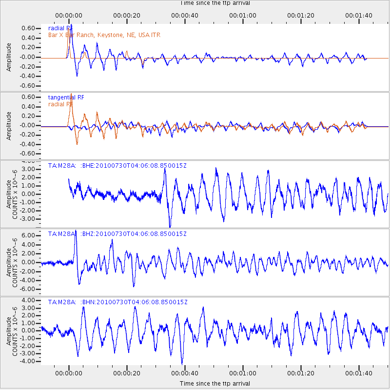
Signal To Noise
| Channel | StoN | STA | LTA |
| TA:M28A: :BHZ:20100730T04:06:08.850015Z | 15.386747 | 2.9758985E-6 | 1.934066E-7 |
| TA:M28A: :BHN:20100730T04:06:08.850015Z | 4.496634 | 1.440978E-6 | 3.2045705E-7 |
| TA:M28A: :BHE:20100730T04:06:08.850015Z | 2.9299493 | 1.4415951E-6 | 4.9202055E-7 |
| Arrivals |
| Ps | 1.6 SECOND |
| PpPs | 6.3 SECOND |
| PsPs/PpSs | 7.9 SECOND |


