You are here: Home > Network List > TA - USArray Transportable Network (new EarthScope stations) Stations List
> Station Q30A Quinter, KS, USA > Earthquake Result Viewer
Q30A Quinter, KS, USA - Earthquake Result Viewer
| Earthquake location: |
Off East Coast Of Kamchatka |
| Earthquake latitude/longitude: |
52.5/159.8 |
| Earthquake time(UTC): |
2010/07/30 (211) 03:56:13 GMT |
| Earthquake Depth: |
23 km |
| Earthquake Magnitude: |
6.1 MB, 6.3 MS, 6.3 MW, 6.3 MW |
| Earthquake Catalog/Contributor: |
WHDF/NEIC |
|
| Network: |
TA USArray Transportable Network (new EarthScope stations) |
| Station: |
Q30A Quinter, KS, USA |
| Lat/Lon: |
38.98 N/100.22 W |
| Elevation: |
797 m |
|
| Distance: |
65.6 deg |
| Az: |
57.484 deg |
| Baz: |
318.594 deg |
| Ray Param: |
0.058154102 |
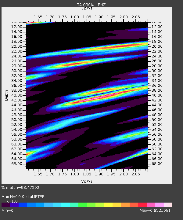
| Estimated Moho Depth: |
10.0 km |
| Estimated Crust Vp/Vs: |
1.60 |
| Assumed Crust Vp: |
6.483 km/s |
| Estimated Crust Vs: |
4.052 km/s |
| Estimated Crust Poisson's Ratio: |
0.18 |
|
| Radial Match: |
93.47202 % |
| Radial Bump: |
388 |
| Transverse Match: |
66.68358 % |
| Transverse Bump: |
377 |
| SOD ConfigId: |
319893 |
| Insert Time: |
2011-01-05 14:41:34.475 +0000 |
| GWidth: |
2.5 |
| Max Bumps: |
400 |
| Tol: |
0.001 |
|
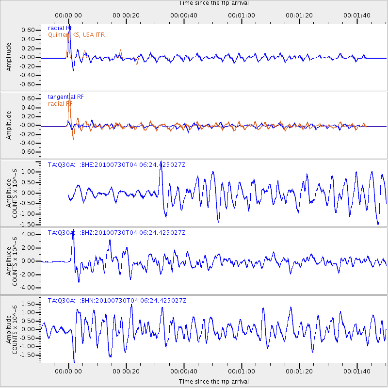
Signal To Noise
| Channel | StoN | STA | LTA |
| TA:Q30A: :BHZ:20100730T04:06:24.425027Z | 15.350125 | 1.8926343E-6 | 1.2329764E-7 |
| TA:Q30A: :BHN:20100730T04:06:24.425027Z | 3.605887 | 8.5277594E-7 | 2.3649548E-7 |
| TA:Q30A: :BHE:20100730T04:06:24.425027Z | 3.9525697 | 7.004614E-7 | 1.772167E-7 |
| Arrivals |
| Ps | 1.0 SECOND |
| PpPs | 3.8 SECOND |
| PsPs/PpSs | 4.8 SECOND |


