You are here: Home > Network List > TA - USArray Transportable Network (new EarthScope stations) Stations List
> Station K29A Lazy Trails Angus Ranch, Wood Lake, NE, USA > Earthquake Result Viewer
K29A Lazy Trails Angus Ranch, Wood Lake, NE, USA - Earthquake Result Viewer

| Earthquake location: |
Off East Coast Of Kamchatka |
| Earthquake latitude/longitude: |
52.5/159.8 |
| Earthquake time(UTC): |
2010/07/30 (211) 03:56:13 GMT |
| Earthquake Depth: |
23 km |
| Earthquake Magnitude: |
6.1 MB, 6.3 MS, 6.3 MW, 6.3 MW |
| Earthquake Catalog/Contributor: |
WHDF/NEIC |
|
| Network: |
TA USArray Transportable Network (new EarthScope stations) |
| Station: |
K29A Lazy Trails Angus Ranch, Wood Lake, NE, USA |
| Lat/Lon: |
42.76 N/100.32 W |
| Elevation: |
840 m |
|
| Distance: |
62.7 deg |
| Az: |
54.732 deg |
| Baz: |
317.33 deg |
| Ray Param: |
0.060015254 |
| Estimated Moho Depth: |
38.5 km |
| Estimated Crust Vp/Vs: |
1.64 |
| Assumed Crust Vp: |
6.483 km/s |
| Estimated Crust Vs: |
3.941 km/s |
| Estimated Crust Poisson's Ratio: |
0.21 |
|
| Radial Match: |
93.60595 % |
| Radial Bump: |
294 |
| Transverse Match: |
85.87838 % |
| Transverse Bump: |
374 |
| SOD ConfigId: |
319893 |
| Insert Time: |
2011-01-05 14:42:32.847 +0000 |
| GWidth: |
2.5 |
| Max Bumps: |
400 |
| Tol: |
0.001 |
|
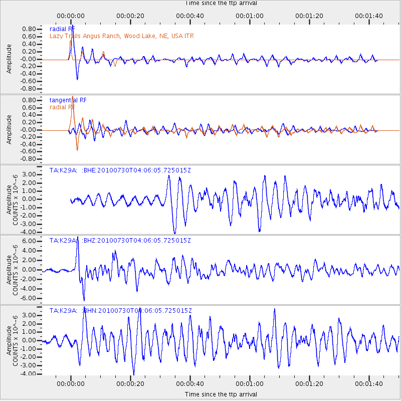
Signal To Noise
| Channel | StoN | STA | LTA |
| TA:K29A: :BHZ:20100730T04:06:05.725015Z | 26.284977 | 3.0679735E-6 | 1.1671966E-7 |
| TA:K29A: :BHN:20100730T04:06:05.725015Z | 4.3983393 | 1.67474E-6 | 3.8076647E-7 |
| TA:K29A: :BHE:20100730T04:06:05.725015Z | 4.113933 | 1.6942226E-6 | 4.1182554E-7 |
| Arrivals |
| Ps | 4.0 SECOND |
| PpPs | 15 SECOND |
| PsPs/PpSs | 19 SECOND |


