You are here: Home > Network List > TA - USArray Transportable Network (new EarthScope stations) Stations List
> Station H28A Mission Ridge, SD, USA > Earthquake Result Viewer
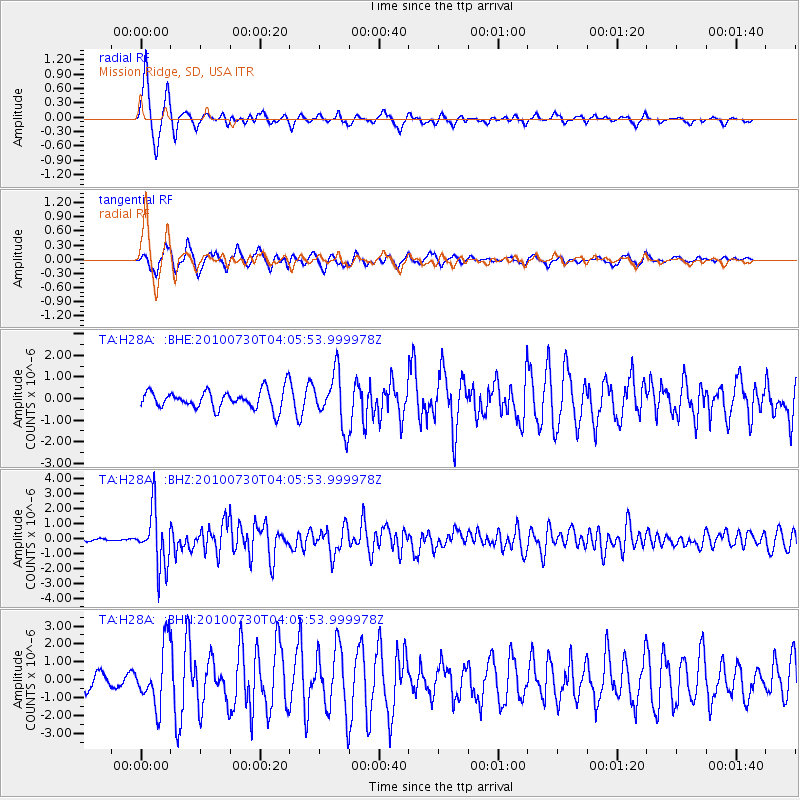
H28A Mission Ridge, SD, USA - Earthquake Result Viewer
| Earthquake location: |
Off East Coast Of Kamchatka |
| Earthquake latitude/longitude: |
52.5/159.8 |
| Earthquake time(UTC): |
2010/07/30 (211) 03:56:13 GMT |
| Earthquake Depth: |
23 km |
| Earthquake Magnitude: |
6.1 MB, 6.3 MS, 6.3 MW, 6.3 MW |
| Earthquake Catalog/Contributor: |
WHDF/NEIC |
|
| Network: |
TA USArray Transportable Network (new EarthScope stations) |
| Station: |
H28A Mission Ridge, SD, USA |
| Lat/Lon: |
44.68 N/101.02 W |
| Elevation: |
642 m |
|
| Distance: |
61.0 deg |
| Az: |
53.669 deg |
| Baz: |
316.344 deg |
| Ray Param: |
0.06114884 |
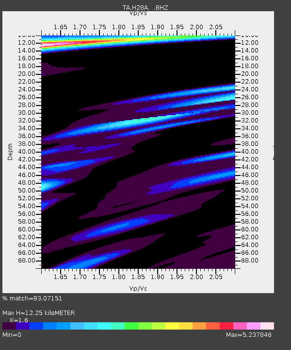
| Estimated Moho Depth: |
12.25 km |
| Estimated Crust Vp/Vs: |
1.60 |
| Assumed Crust Vp: |
6.53 km/s |
| Estimated Crust Vs: |
4.082 km/s |
| Estimated Crust Poisson's Ratio: |
0.18 |
|
| Radial Match: |
93.07151 % |
| Radial Bump: |
364 |
| Transverse Match: |
85.44829 % |
| Transverse Bump: |
351 |
| SOD ConfigId: |
319893 |
| Insert Time: |
2011-01-05 14:43:31.900 +0000 |
| GWidth: |
2.5 |
| Max Bumps: |
400 |
| Tol: |
0.001 |
|
Signal To Noise
| Channel | StoN | STA | LTA |
| TA:H28A: :BHZ:20100730T04:05:53.999978Z | 30.04471 | 1.8476728E-6 | 6.1497445E-8 |
| TA:H28A: :BHN:20100730T04:05:53.999978Z | 3.619162 | 1.6663023E-6 | 4.604111E-7 |
| TA:H28A: :BHE:20100730T04:05:53.999978Z | 2.8141265 | 1.2177961E-6 | 4.3274395E-7 |
| Arrivals |
| Ps | 1.2 SECOND |
| PpPs | 4.6 SECOND |
| PsPs/PpSs | 5.8 SECOND |


