You are here: Home > Network List > AZ - ANZA Regional Network Stations List
> Station BVDA2 AZ.BVDA2 > Earthquake Result Viewer
BVDA2 AZ.BVDA2 - Earthquake Result Viewer
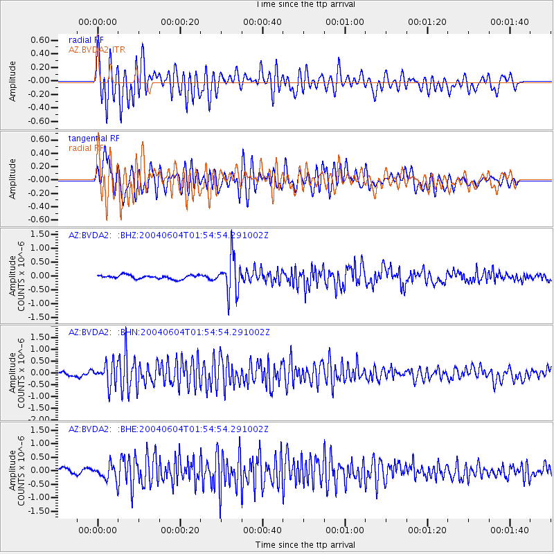
| Earthquake location: |
Unimak Island Region, Alaska |
| Earthquake latitude/longitude: |
54.5/-163.9 |
| Earthquake time(UTC): |
2004/06/04 (156) 01:48:03 GMT |
| Earthquake Depth: |
73 km |
| Earthquake Magnitude: |
5.2 MB, 5.6 MW, 5.5 MW |
| Earthquake Catalog/Contributor: |
WHDF/NEIC |
|
| Network: |
AZ ANZA Regional Network |
| Station: |
BVDA2 AZ.BVDA2 |
| Lat/Lon: |
33.33 N/116.37 W |
| Elevation: |
0.0 m |
|
| Distance: |
39.3 deg |
| Az: |
102.79 deg |
| Baz: |
317.156 deg |
| Ray Param: |
0.074866794 |
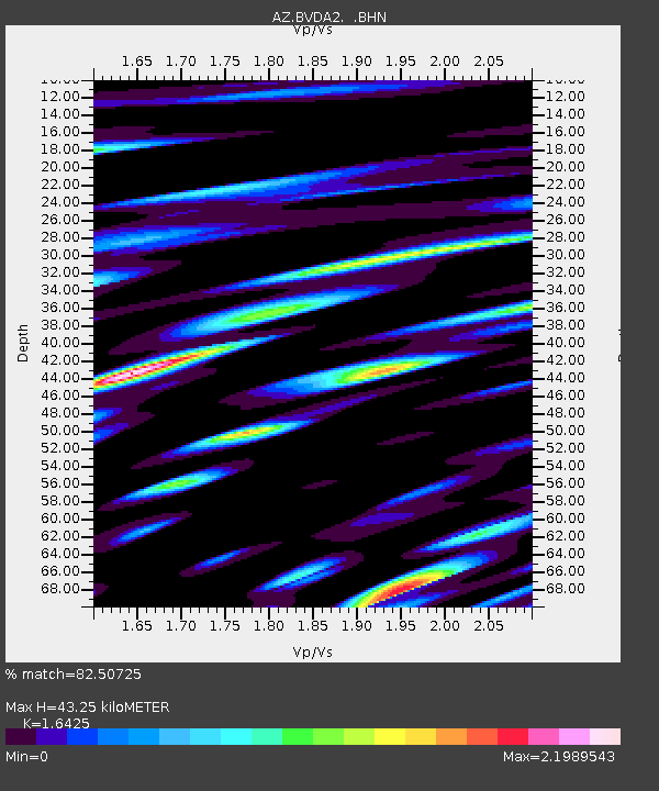
| Estimated Moho Depth: |
43.25 km |
| Estimated Crust Vp/Vs: |
1.64 |
| Assumed Crust Vp: |
6.264 km/s |
| Estimated Crust Vs: |
3.813 km/s |
| Estimated Crust Poisson's Ratio: |
0.21 |
|
| Radial Match: |
82.50725 % |
| Radial Bump: |
400 |
| Transverse Match: |
77.11806 % |
| Transverse Bump: |
400 |
| SOD ConfigId: |
32974 |
| Insert Time: |
2010-02-26 18:38:27.017 +0000 |
| GWidth: |
2.5 |
| Max Bumps: |
400 |
| Tol: |
0.001 |
|
Signal To Noise
| Channel | StoN | STA | LTA |
| AZ:BVDA2: :BHN:20040604T01:54:54.291002Z | 4.3477397 | 4.6992457E-7 | 1.080848E-7 |
| AZ:BVDA2: :BHE:20040604T01:54:54.291002Z | 2.557093 | 2.8322557E-7 | 1.1076077E-7 |
| AZ:BVDA2: :BHZ:20040604T01:54:54.291002Z | 9.743807 | 6.7262755E-7 | 6.903129E-8 |
| Arrivals |
| Ps | 4.8 SECOND |
| PpPs | 17 SECOND |
| PsPs/PpSs | 22 SECOND |


