You are here: Home > Network List > TA - USArray Transportable Network (new EarthScope stations) Stations List
> Station G25A Newell, SD, USA > Earthquake Result Viewer
G25A Newell, SD, USA - Earthquake Result Viewer
| Earthquake location: |
Off East Coast Of Kamchatka |
| Earthquake latitude/longitude: |
52.5/159.8 |
| Earthquake time(UTC): |
2010/07/30 (211) 03:56:13 GMT |
| Earthquake Depth: |
23 km |
| Earthquake Magnitude: |
6.1 MB, 6.3 MS, 6.3 MW, 6.3 MW |
| Earthquake Catalog/Contributor: |
WHDF/NEIC |
|
| Network: |
TA USArray Transportable Network (new EarthScope stations) |
| Station: |
G25A Newell, SD, USA |
| Lat/Lon: |
45.19 N/103.42 W |
| Elevation: |
894 m |
|
| Distance: |
59.4 deg |
| Az: |
54.657 deg |
| Baz: |
315.149 deg |
| Ray Param: |
0.062173955 |
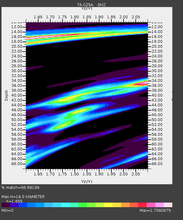
| Estimated Moho Depth: |
16.0 km |
| Estimated Crust Vp/Vs: |
1.65 |
| Assumed Crust Vp: |
6.242 km/s |
| Estimated Crust Vs: |
3.772 km/s |
| Estimated Crust Poisson's Ratio: |
0.21 |
|
| Radial Match: |
88.96186 % |
| Radial Bump: |
287 |
| Transverse Match: |
75.43782 % |
| Transverse Bump: |
393 |
| SOD ConfigId: |
319893 |
| Insert Time: |
2011-01-05 14:44:17.055 +0000 |
| GWidth: |
2.5 |
| Max Bumps: |
400 |
| Tol: |
0.001 |
|
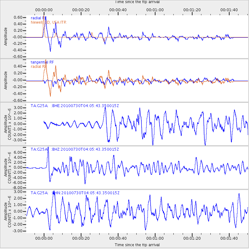
Signal To Noise
| Channel | StoN | STA | LTA |
| TA:G25A: :BHZ:20100730T04:05:43.350015Z | 14.321577 | 3.3672534E-6 | 2.351175E-7 |
| TA:G25A: :BHN:20100730T04:05:43.350015Z | 2.5948858 | 1.1975812E-6 | 4.6151595E-7 |
| TA:G25A: :BHE:20100730T04:05:43.350015Z | 5.215972 | 1.6096965E-6 | 3.0860912E-7 |
| Arrivals |
| Ps | 1.8 SECOND |
| PpPs | 6.5 SECOND |
| PsPs/PpSs | 8.2 SECOND |


