You are here: Home > Network List > TA - USArray Transportable Network (new EarthScope stations) Stations List
> Station D27A Center, ND, USA > Earthquake Result Viewer
D27A Center, ND, USA - Earthquake Result Viewer
| Earthquake location: |
Off East Coast Of Kamchatka |
| Earthquake latitude/longitude: |
52.5/159.8 |
| Earthquake time(UTC): |
2010/07/30 (211) 03:56:13 GMT |
| Earthquake Depth: |
23 km |
| Earthquake Magnitude: |
6.1 MB, 6.3 MS, 6.3 MW, 6.3 MW |
| Earthquake Catalog/Contributor: |
WHDF/NEIC |
|
| Network: |
TA USArray Transportable Network (new EarthScope stations) |
| Station: |
D27A Center, ND, USA |
| Lat/Lon: |
47.11 N/101.53 W |
| Elevation: |
685 m |
|
| Distance: |
59.0 deg |
| Az: |
51.999 deg |
| Baz: |
315.148 deg |
| Ray Param: |
0.062458325 |
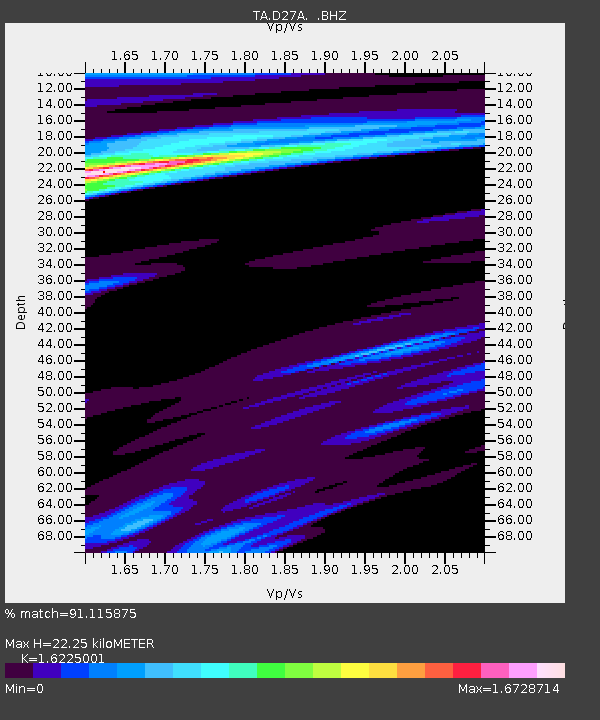
| Estimated Moho Depth: |
22.25 km |
| Estimated Crust Vp/Vs: |
1.62 |
| Assumed Crust Vp: |
6.438 km/s |
| Estimated Crust Vs: |
3.968 km/s |
| Estimated Crust Poisson's Ratio: |
0.19 |
|
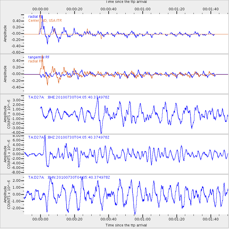
| Radial Match: |
91.115875 % |
| Radial Bump: |
310 |
| Transverse Match: |
65.49495 % |
| Transverse Bump: |
400 |
| SOD ConfigId: |
319893 |
| Insert Time: |
2011-01-05 14:44:29.766 +0000 |
| GWidth: |
2.5 |
| Max Bumps: |
400 |
| Tol: |
0.001 |
|
Signal To Noise
| Channel | StoN | STA | LTA |
| TA:D27A: :BHZ:20100730T04:05:40.374978Z | 9.697224 | 3.652969E-6 | 3.767026E-7 |
| TA:D27A: :BHN:20100730T04:05:40.374978Z | 2.5765095 | 8.674986E-7 | 3.366953E-7 |
| TA:D27A: :BHE:20100730T04:05:40.374978Z | 2.002929 | 1.4893726E-6 | 7.4359735E-7 |
| Arrivals |
| Ps | 2.3 SECOND |
| PpPs | 8.6 SECOND |
| PsPs/PpSs | 11 SECOND |


