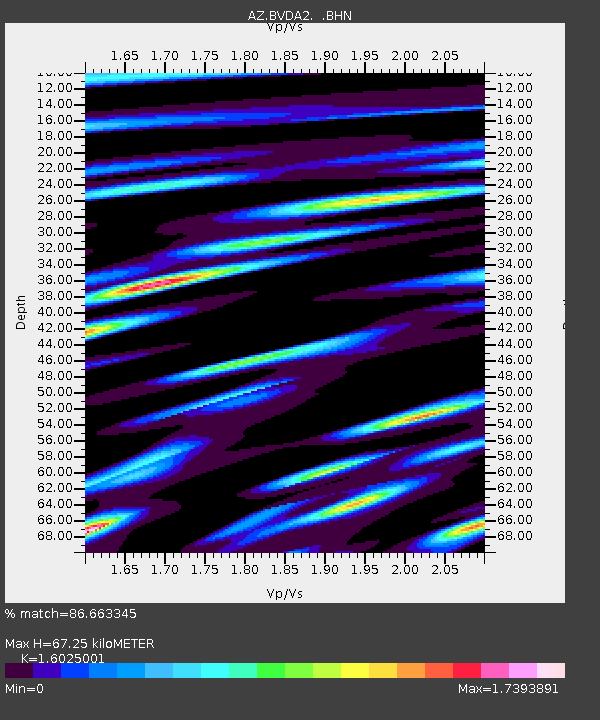
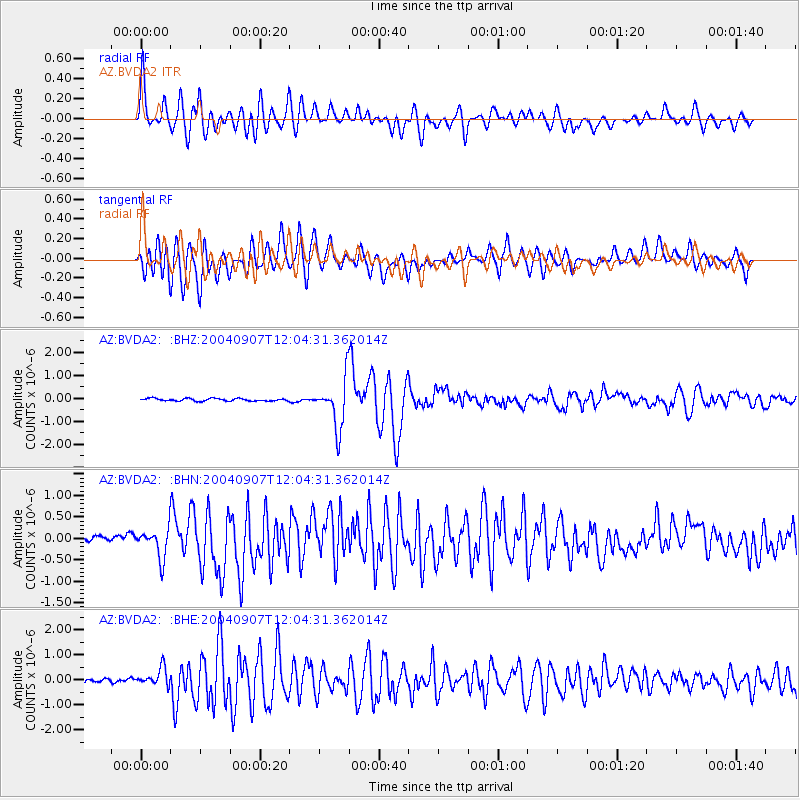
BVDA2 AZ.BVDA2 - Earthquake Result Viewer

Earthquake location: Santiago Del Estero Prov., Arg.
Earthquake latitude/longitude: -28.6/-65.8
Earthquake time(UTC): 2004/09/07 (251) 11:53:06 GMT
Earthquake Depth: 22 km
Earthquake Magnitude: 6.1 MB, 6.1 MS, 6.4 MW, 6.2 MW
Earthquake Catalog/Contributor: WHDF/NEIC
Network: AZ ANZA Regional Network
Station: BVDA2 AZ.BVDA2
Lat/Lon: 33.33 N/116.37 W
Elevation: 0.0 m
Distance: 78.0 deg
Az: 318.645 deg
Baz: 136.044 deg
Ray Param: 0.049918618
Estimated Moho Depth: 67.25 km
Estimated Crust Vp/Vs: 1.60
Assumed Crust Vp: 6.264 km/s
Estimated Crust Vs: 3.909 km/s
Estimated Crust Poisson's Ratio: 0.18
Radial Match: 86.663345 %
Radial Bump: 400
Transverse Match: 83.09829 %
Transverse Bump: 400
SOD ConfigId: 2459
Insert Time: 2010-02-26 18:38:28.628 +0000
GWidth: 2.5
Max Bumps: 400
Tol: 0.001

Signal To Noise

ChannelStoNSTALTA
AZ:BVDA2: :BHN:20040907T12:04:31.362014Z2.5248433.3632477E-71.3320621E-7
AZ:BVDA2: :BHE:20040907T12:04:31.362014Z4.6488913.5676175E-77.674125E-8
AZ:BVDA2: :BHZ:20040907T12:04:31.362014Z18.461031.0580881E-65.731469E-8
Arrivals
Ps6.7 SECOND
PpPs27 SECOND
PsPs/PpSs34 SECOND