You are here: Home > Network List > TA - USArray Transportable Network (new EarthScope stations) Stations List
> Station A27A Ledoux Ranch, Antler, ND, USA > Earthquake Result Viewer
A27A Ledoux Ranch, Antler, ND, USA - Earthquake Result Viewer

| Earthquake location: |
Off East Coast Of Kamchatka |
| Earthquake latitude/longitude: |
52.5/159.8 |
| Earthquake time(UTC): |
2010/07/30 (211) 03:56:13 GMT |
| Earthquake Depth: |
23 km |
| Earthquake Magnitude: |
6.1 MB, 6.3 MS, 6.3 MW, 6.3 MW |
| Earthquake Catalog/Contributor: |
WHDF/NEIC |
|
| Network: |
TA USArray Transportable Network (new EarthScope stations) |
| Station: |
A27A Ledoux Ranch, Antler, ND, USA |
| Lat/Lon: |
48.95 N/101.24 W |
| Elevation: |
466 m |
|
| Distance: |
57.8 deg |
| Az: |
50.303 deg |
| Baz: |
314.47 deg |
| Ray Param: |
0.063217975 |
| Estimated Moho Depth: |
47.25 km |
| Estimated Crust Vp/Vs: |
1.81 |
| Assumed Crust Vp: |
6.438 km/s |
| Estimated Crust Vs: |
3.562 km/s |
| Estimated Crust Poisson's Ratio: |
0.28 |
|
| Radial Match: |
80.012085 % |
| Radial Bump: |
317 |
| Transverse Match: |
70.88066 % |
| Transverse Bump: |
378 |
| SOD ConfigId: |
319893 |
| Insert Time: |
2011-01-05 14:45:27.568 +0000 |
| GWidth: |
2.5 |
| Max Bumps: |
400 |
| Tol: |
0.001 |
|
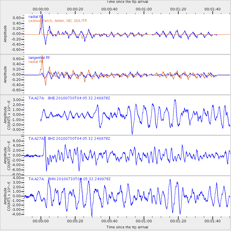
Signal To Noise
| Channel | StoN | STA | LTA |
| TA:A27A: :BHZ:20100730T04:05:32.249978Z | 17.431469 | 3.2810597E-6 | 1.8822622E-7 |
| TA:A27A: :BHN:20100730T04:05:32.249978Z | 1.5412822 | 1.5812552E-6 | 1.025935E-6 |
| TA:A27A: :BHE:20100730T04:05:32.249978Z | 2.7595892 | 1.2319161E-6 | 4.4641288E-7 |
| Arrivals |
| Ps | 6.2 SECOND |
| PpPs | 20 SECOND |
| PsPs/PpSs | 26 SECOND |


