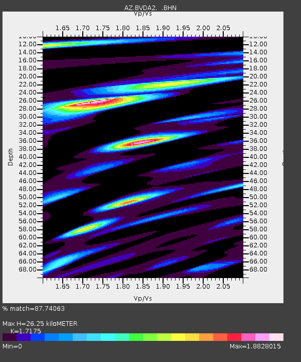
BVDA2 AZ.BVDA2 - Earthquake Result Viewer
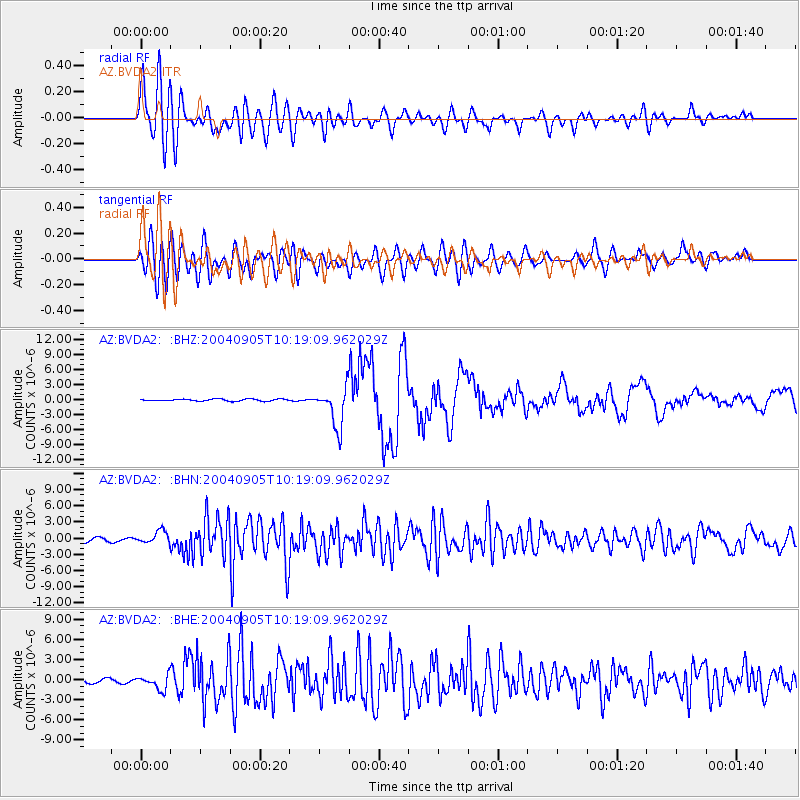
Earthquake location: Near S. Coast Of Western Honshu
Earthquake latitude/longitude: 33.1/136.6
Earthquake time(UTC): 2004/09/05 (249) 10:07:07 GMT
Earthquake Depth: 14 km
Earthquake Magnitude: 6.7 MB, 7.0 MS, 7.2 MW, 7.0 MW
Earthquake Catalog/Contributor: WHDF/NEIC
Network: AZ ANZA Regional Network
Station: BVDA2 AZ.BVDA2
Lat/Lon: 33.33 N/116.37 W
Elevation: 0.0 m
Distance: 84.8 deg
Az: 53.508 deg
Baz: 306.266 deg
Ray Param: 0.04524124
Estimated Moho Depth: 26.25 km
Estimated Crust Vp/Vs: 1.72
Assumed Crust Vp: 6.264 km/s
Estimated Crust Vs: 3.647 km/s
Estimated Crust Poisson's Ratio: 0.24
Radial Match: 87.74063 %
Radial Bump: 400
Transverse Match: 80.93477 %
Transverse Bump: 400
SOD ConfigId: 2459
Insert Time: 2010-02-26 18:38:30.460 +0000
GWidth: 2.5
Max Bumps: 400
Tol: 0.001

Signal To Noise

ChannelStoNSTALTA
AZ:BVDA2: :BHN:20040905T10:19:09.962029Z3.29091331.1616135E-63.52976E-7
AZ:BVDA2: :BHE:20040905T10:19:09.962029Z5.0362431.0945424E-62.1733312E-7
AZ:BVDA2: :BHZ:20040905T10:19:09.962029Z20.322633.9892034E-61.9629367E-7
Arrivals
Ps3.1 SECOND
PpPs11 SECOND
PsPs/PpSs14 SECOND