You are here: Home > Network List > TA - USArray Transportable Network (new EarthScope stations) Stations List
> Station A29A Manning Farm, Rocklake, ND, USA > Earthquake Result Viewer
A29A Manning Farm, Rocklake, ND, USA - Earthquake Result Viewer
| Earthquake location: |
Off East Coast Of Kamchatka |
| Earthquake latitude/longitude: |
52.5/159.8 |
| Earthquake time(UTC): |
2010/07/30 (211) 03:56:13 GMT |
| Earthquake Depth: |
23 km |
| Earthquake Magnitude: |
6.1 MB, 6.3 MS, 6.3 MW, 6.3 MW |
| Earthquake Catalog/Contributor: |
WHDF/NEIC |
|
| Network: |
TA USArray Transportable Network (new EarthScope stations) |
| Station: |
A29A Manning Farm, Rocklake, ND, USA |
| Lat/Lon: |
48.92 N/99.23 W |
| Elevation: |
480 m |
|
| Distance: |
58.8 deg |
| Az: |
49.229 deg |
| Baz: |
315.415 deg |
| Ray Param: |
0.06259315 |
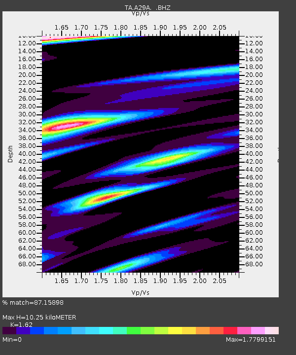
| Estimated Moho Depth: |
10.25 km |
| Estimated Crust Vp/Vs: |
1.62 |
| Assumed Crust Vp: |
6.53 km/s |
| Estimated Crust Vs: |
4.031 km/s |
| Estimated Crust Poisson's Ratio: |
0.19 |
|
| Radial Match: |
87.15898 % |
| Radial Bump: |
309 |
| Transverse Match: |
80.771355 % |
| Transverse Bump: |
353 |
| SOD ConfigId: |
319893 |
| Insert Time: |
2011-01-05 14:45:59.973 +0000 |
| GWidth: |
2.5 |
| Max Bumps: |
400 |
| Tol: |
0.001 |
|
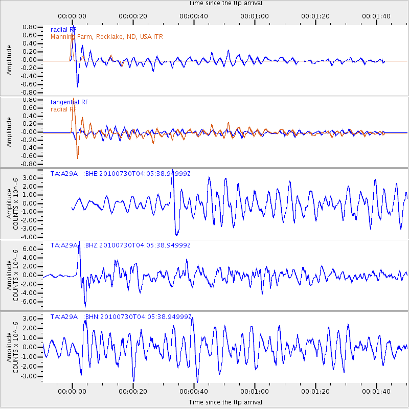
Signal To Noise
| Channel | StoN | STA | LTA |
| TA:A29A: :BHZ:20100730T04:05:38.94999Z | 19.089417 | 3.286717E-6 | 1.7217482E-7 |
| TA:A29A: :BHN:20100730T04:05:38.94999Z | 2.5996926 | 1.5324916E-6 | 5.8948956E-7 |
| TA:A29A: :BHE:20100730T04:05:38.94999Z | 4.1176577 | 2.001266E-6 | 4.860205E-7 |
| Arrivals |
| Ps | 1.0 SECOND |
| PpPs | 3.9 SECOND |
| PsPs/PpSs | 4.9 SECOND |


