You are here: Home > Network List > TA - USArray Transportable Network (new EarthScope stations) Stations List
> Station E30A Jud, ND, USA > Earthquake Result Viewer
E30A Jud, ND, USA - Earthquake Result Viewer
| Earthquake location: |
Off East Coast Of Kamchatka |
| Earthquake latitude/longitude: |
52.5/159.8 |
| Earthquake time(UTC): |
2010/07/30 (211) 03:56:13 GMT |
| Earthquake Depth: |
23 km |
| Earthquake Magnitude: |
6.1 MB, 6.3 MS, 6.3 MW, 6.3 MW |
| Earthquake Catalog/Contributor: |
WHDF/NEIC |
|
| Network: |
TA USArray Transportable Network (new EarthScope stations) |
| Station: |
E30A Jud, ND, USA |
| Lat/Lon: |
46.50 N/98.91 W |
| Elevation: |
544 m |
|
| Distance: |
60.7 deg |
| Az: |
50.997 deg |
| Baz: |
316.545 deg |
| Ray Param: |
0.061348904 |
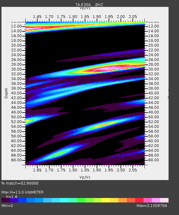
| Estimated Moho Depth: |
13.0 km |
| Estimated Crust Vp/Vs: |
1.60 |
| Assumed Crust Vp: |
6.53 km/s |
| Estimated Crust Vs: |
4.082 km/s |
| Estimated Crust Poisson's Ratio: |
0.18 |
|
| Radial Match: |
82.98888 % |
| Radial Bump: |
321 |
| Transverse Match: |
71.55271 % |
| Transverse Bump: |
392 |
| SOD ConfigId: |
319893 |
| Insert Time: |
2011-01-05 14:46:11.171 +0000 |
| GWidth: |
2.5 |
| Max Bumps: |
400 |
| Tol: |
0.001 |
|
Signal To Noise
| Channel | StoN | STA | LTA |
| TA:E30A: :BHZ:20100730T04:05:51.94999Z | 17.559889 | 2.783731E-6 | 1.5852783E-7 |
| TA:E30A: :BHN:20100730T04:05:51.94999Z | 3.0249605 | 1.7349801E-6 | 5.735546E-7 |
| TA:E30A: :BHE:20100730T04:05:51.94999Z | 3.5252273 | 1.9065317E-6 | 5.408252E-7 |
| Arrivals |
| Ps | 1.3 SECOND |
| PpPs | 4.9 SECOND |
| PsPs/PpSs | 6.2 SECOND |


