You are here: Home > Network List > UW - Pacific Northwest Regional Seismic Network Stations List
> Station UMAT Pilot Rock, OR, USA > Earthquake Result Viewer
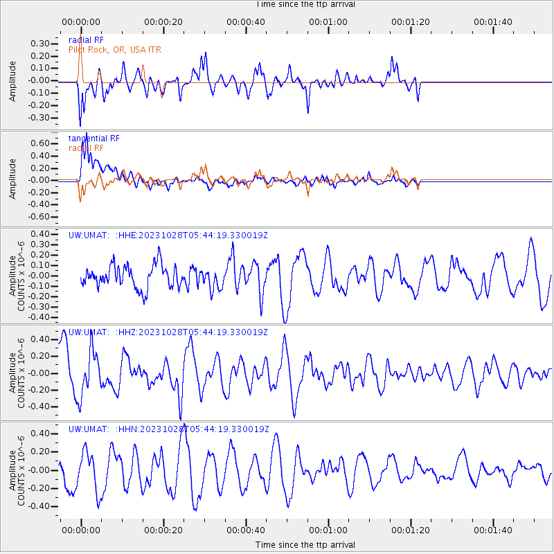
UMAT Pilot Rock, OR, USA - Earthquake Result Viewer
*The percent match for this event was below the threshold and hence no stack was calculated.
| Earthquake location: |
Solomon Islands |
| Earthquake latitude/longitude: |
-10.2/161.3 |
| Earthquake time(UTC): |
2023/10/28 (301) 05:31:58 GMT |
| Earthquake Depth: |
69 km |
| Earthquake Magnitude: |
5.5 mww |
| Earthquake Catalog/Contributor: |
NEIC PDE/us |
|
| Network: |
UW Pacific Northwest Regional Seismic Network |
| Station: |
UMAT Pilot Rock, OR, USA |
| Lat/Lon: |
45.29 N/118.96 W |
| Elevation: |
1318 m |
|
| Distance: |
90.1 deg |
| Az: |
43.997 deg |
| Baz: |
255.604 deg |
| Ray Param: |
$rayparam |
*The percent match for this event was below the threshold and hence was not used in the summary stack. |
|
| Radial Match: |
66.98482 % |
| Radial Bump: |
400 |
| Transverse Match: |
64.773834 % |
| Transverse Bump: |
400 |
| SOD ConfigId: |
31937991 |
| Insert Time: |
2023-11-11 05:50:30.796 +0000 |
| GWidth: |
2.5 |
| Max Bumps: |
400 |
| Tol: |
0.001 |
|
Signal To Noise
| Channel | StoN | STA | LTA |
| UW:UMAT: :HHZ:20231028T05:44:19.330019Z | 1.5536673 | 2.6909922E-7 | 1.732026E-7 |
| UW:UMAT: :HHN:20231028T05:44:19.330019Z | 1.1047395 | 2.1692233E-7 | 1.9635608E-7 |
| UW:UMAT: :HHE:20231028T05:44:19.330019Z | 0.9060514 | 9.7554405E-8 | 1.07669834E-7 |
| Arrivals |
| Ps | |
| PpPs | |
| PsPs/PpSs | |


