You are here: Home > Network List > TA - USArray Transportable Network (new EarthScope stations) Stations List
> Station X32A Elmer, OK, USA > Earthquake Result Viewer
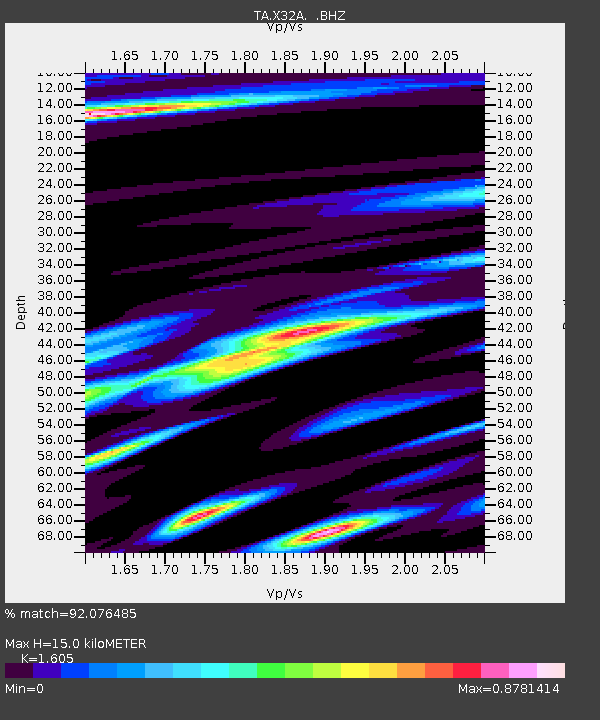
X32A Elmer, OK, USA - Earthquake Result Viewer
| Earthquake location: |
Off East Coast Of Kamchatka |
| Earthquake latitude/longitude: |
52.5/159.8 |
| Earthquake time(UTC): |
2010/07/30 (211) 03:56:13 GMT |
| Earthquake Depth: |
23 km |
| Earthquake Magnitude: |
6.1 MB, 6.3 MS, 6.3 MW, 6.3 MW |
| Earthquake Catalog/Contributor: |
WHDF/NEIC |
|
| Network: |
TA USArray Transportable Network (new EarthScope stations) |
| Station: |
X32A Elmer, OK, USA |
| Lat/Lon: |
34.42 N/99.29 W |
| Elevation: |
401 m |
|
| Distance: |
69.5 deg |
| Az: |
60.07 deg |
| Baz: |
320.14 deg |
| Ray Param: |
0.05556922 |
| Estimated Moho Depth: |
15.0 km |
| Estimated Crust Vp/Vs: |
1.61 |
| Assumed Crust Vp: |
6.315 km/s |
| Estimated Crust Vs: |
3.935 km/s |
| Estimated Crust Poisson's Ratio: |
0.18 |
|
| Radial Match: |
92.076485 % |
| Radial Bump: |
381 |
| Transverse Match: |
86.702126 % |
| Transverse Bump: |
400 |
| SOD ConfigId: |
319893 |
| Insert Time: |
2011-01-05 14:49:03.189 +0000 |
| GWidth: |
2.5 |
| Max Bumps: |
400 |
| Tol: |
0.001 |
|

Signal To Noise
| Channel | StoN | STA | LTA |
| TA:X32A: :BHZ:20100730T04:06:49.249978Z | 21.233192 | 2.053189E-6 | 9.669715E-8 |
| TA:X32A: :BHN:20100730T04:06:49.249978Z | 4.4806466 | 5.135653E-7 | 1.1461855E-7 |
| TA:X32A: :BHE:20100730T04:06:49.249978Z | 5.468325 | 6.856637E-7 | 1.2538824E-7 |
| Arrivals |
| Ps | 1.5 SECOND |
| PpPs | 5.9 SECOND |
| PsPs/PpSs | 7.4 SECOND |


