You are here: Home > Network List > TA - USArray Transportable Network (new EarthScope stations) Stations List
> Station Q33A Connelly Farm, Tescott, KS, USA > Earthquake Result Viewer
Q33A Connelly Farm, Tescott, KS, USA - Earthquake Result Viewer
| Earthquake location: |
Off East Coast Of Kamchatka |
| Earthquake latitude/longitude: |
52.5/159.8 |
| Earthquake time(UTC): |
2010/07/30 (211) 03:56:13 GMT |
| Earthquake Depth: |
23 km |
| Earthquake Magnitude: |
6.1 MB, 6.3 MS, 6.3 MW, 6.3 MW |
| Earthquake Catalog/Contributor: |
WHDF/NEIC |
|
| Network: |
TA USArray Transportable Network (new EarthScope stations) |
| Station: |
Q33A Connelly Farm, Tescott, KS, USA |
| Lat/Lon: |
39.00 N/97.83 W |
| Elevation: |
422 m |
|
| Distance: |
66.8 deg |
| Az: |
55.933 deg |
| Baz: |
319.464 deg |
| Ray Param: |
0.057361733 |
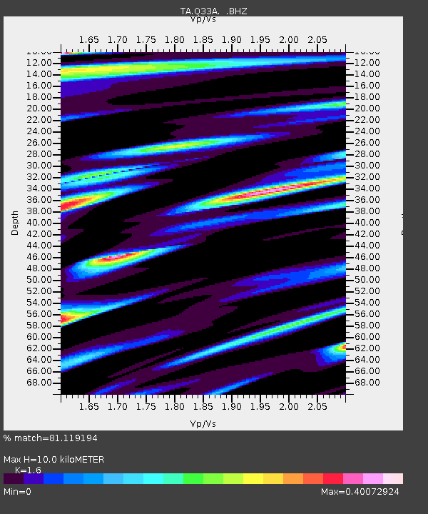
| Estimated Moho Depth: |
10.0 km |
| Estimated Crust Vp/Vs: |
1.60 |
| Assumed Crust Vp: |
6.483 km/s |
| Estimated Crust Vs: |
4.052 km/s |
| Estimated Crust Poisson's Ratio: |
0.18 |
|
| Radial Match: |
81.119194 % |
| Radial Bump: |
400 |
| Transverse Match: |
77.637115 % |
| Transverse Bump: |
400 |
| SOD ConfigId: |
319893 |
| Insert Time: |
2011-01-05 14:49:26.412 +0000 |
| GWidth: |
2.5 |
| Max Bumps: |
400 |
| Tol: |
0.001 |
|

Signal To Noise
| Channel | StoN | STA | LTA |
| TA:Q33A: :BHZ:20100730T04:06:32.124978Z | 8.467123 | 1.8324127E-6 | 2.1641503E-7 |
| TA:Q33A: :BHN:20100730T04:06:32.124978Z | 3.8921993 | 7.163376E-7 | 1.8404442E-7 |
| TA:Q33A: :BHE:20100730T04:06:32.124978Z | 3.9953074 | 6.0989606E-7 | 1.526531E-7 |
| Arrivals |
| Ps | 1.0 SECOND |
| PpPs | 3.8 SECOND |
| PsPs/PpSs | 4.8 SECOND |


