You are here: Home > Network List > TA - USArray Transportable Network (new EarthScope stations) Stations List
> Station V34A Guthrie, OK, USA > Earthquake Result Viewer
V34A Guthrie, OK, USA - Earthquake Result Viewer
| Earthquake location: |
Off East Coast Of Kamchatka |
| Earthquake latitude/longitude: |
52.5/159.8 |
| Earthquake time(UTC): |
2010/07/30 (211) 03:56:13 GMT |
| Earthquake Depth: |
23 km |
| Earthquake Magnitude: |
6.1 MB, 6.3 MS, 6.3 MW, 6.3 MW |
| Earthquake Catalog/Contributor: |
WHDF/NEIC |
|
| Network: |
TA USArray Transportable Network (new EarthScope stations) |
| Station: |
V34A Guthrie, OK, USA |
| Lat/Lon: |
35.83 N/97.52 W |
| Elevation: |
329 m |
|
| Distance: |
69.4 deg |
| Az: |
57.917 deg |
| Baz: |
320.396 deg |
| Ray Param: |
0.055673867 |
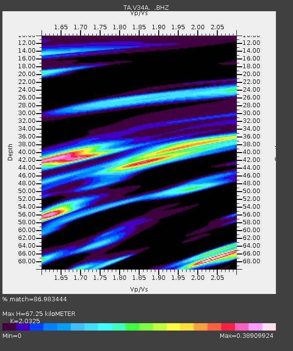
| Estimated Moho Depth: |
67.25 km |
| Estimated Crust Vp/Vs: |
2.03 |
| Assumed Crust Vp: |
6.426 km/s |
| Estimated Crust Vs: |
3.162 km/s |
| Estimated Crust Poisson's Ratio: |
0.34 |
|
| Radial Match: |
86.983444 % |
| Radial Bump: |
362 |
| Transverse Match: |
83.819466 % |
| Transverse Bump: |
352 |
| SOD ConfigId: |
319893 |
| Insert Time: |
2011-01-05 14:49:39.459 +0000 |
| GWidth: |
2.5 |
| Max Bumps: |
400 |
| Tol: |
0.001 |
|
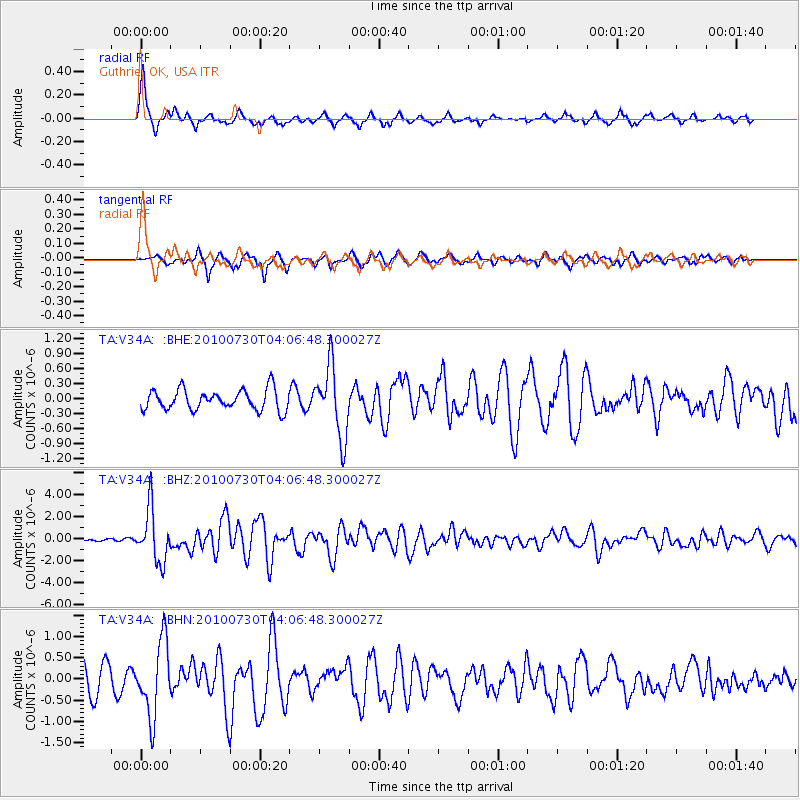
Signal To Noise
| Channel | StoN | STA | LTA |
| TA:V34A: :BHZ:20100730T04:06:48.300027Z | 22.027283 | 2.4049425E-6 | 1.0918017E-7 |
| TA:V34A: :BHN:20100730T04:06:48.300027Z | 3.4446542 | 8.6868204E-7 | 2.5218264E-7 |
| TA:V34A: :BHE:20100730T04:06:48.300027Z | 3.4772558 | 7.0815963E-7 | 2.0365474E-7 |
| Arrivals |
| Ps | 11 SECOND |
| PpPs | 31 SECOND |
| PsPs/PpSs | 42 SECOND |


