You are here: Home > Network List > TA - USArray Transportable Network (new EarthScope stations) Stations List
> Station L02D Cave Junction, OR, USA > Earthquake Result Viewer
L02D Cave Junction, OR, USA - Earthquake Result Viewer
| Earthquake location: |
Off East Coast Of Kamchatka |
| Earthquake latitude/longitude: |
52.5/159.8 |
| Earthquake time(UTC): |
2010/07/30 (211) 03:56:13 GMT |
| Earthquake Depth: |
23 km |
| Earthquake Magnitude: |
6.1 MB, 6.3 MS, 6.3 MW, 6.3 MW |
| Earthquake Catalog/Contributor: |
WHDF/NEIC |
|
| Network: |
TA USArray Transportable Network (new EarthScope stations) |
| Station: |
L02D Cave Junction, OR, USA |
| Lat/Lon: |
42.16 N/123.60 W |
| Elevation: |
458 m |
|
| Distance: |
50.6 deg |
| Az: |
69.388 deg |
| Baz: |
309.682 deg |
| Ray Param: |
0.06791985 |
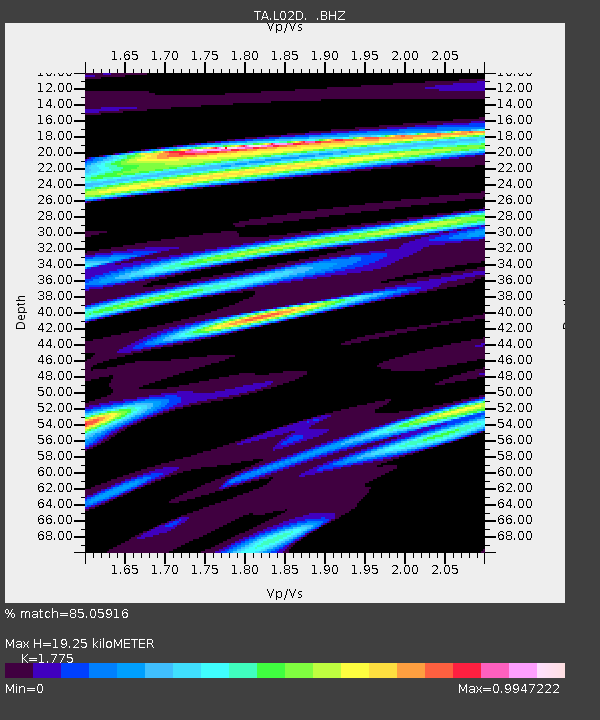
| Estimated Moho Depth: |
19.25 km |
| Estimated Crust Vp/Vs: |
1.77 |
| Assumed Crust Vp: |
6.522 km/s |
| Estimated Crust Vs: |
3.674 km/s |
| Estimated Crust Poisson's Ratio: |
0.27 |
|
| Radial Match: |
85.05916 % |
| Radial Bump: |
400 |
| Transverse Match: |
74.05481 % |
| Transverse Bump: |
400 |
| SOD ConfigId: |
319893 |
| Insert Time: |
2011-01-05 14:50:39.874 +0000 |
| GWidth: |
2.5 |
| Max Bumps: |
400 |
| Tol: |
0.001 |
|
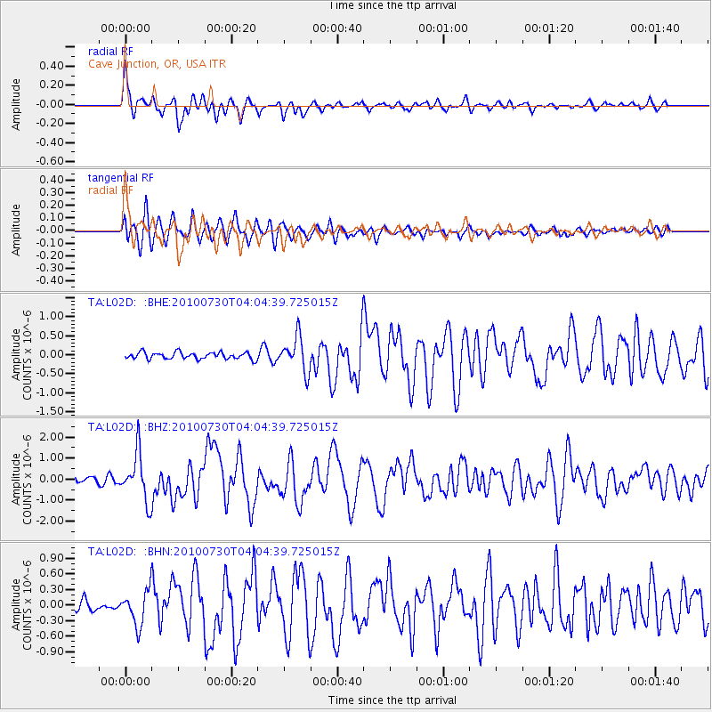
Signal To Noise
| Channel | StoN | STA | LTA |
| TA:L02D: :BHZ:20100730T04:04:39.725015Z | 9.41853 | 1.1541117E-6 | 1.2253629E-7 |
| TA:L02D: :BHN:20100730T04:04:39.725015Z | 2.7398226 | 3.3444238E-7 | 1.2206716E-7 |
| TA:L02D: :BHE:20100730T04:04:39.725015Z | 5.1515594 | 4.5675316E-7 | 8.8663086E-8 |
| Arrivals |
| Ps | 2.4 SECOND |
| PpPs | 7.7 SECOND |
| PsPs/PpSs | 10 SECOND |


