You are here: Home > Network List > TA - USArray Transportable Network (new EarthScope stations) Stations List
> Station 334A Lometa, TX, USA > Earthquake Result Viewer
334A Lometa, TX, USA - Earthquake Result Viewer
| Earthquake location: |
Off East Coast Of Kamchatka |
| Earthquake latitude/longitude: |
52.5/159.8 |
| Earthquake time(UTC): |
2010/07/30 (211) 03:56:13 GMT |
| Earthquake Depth: |
23 km |
| Earthquake Magnitude: |
6.1 MB, 6.3 MS, 6.3 MW, 6.3 MW |
| Earthquake Catalog/Contributor: |
WHDF/NEIC |
|
| Network: |
TA USArray Transportable Network (new EarthScope stations) |
| Station: |
334A Lometa, TX, USA |
| Lat/Lon: |
31.33 N/98.24 W |
| Elevation: |
389 m |
|
| Distance: |
72.5 deg |
| Az: |
61.415 deg |
| Baz: |
321.144 deg |
| Ray Param: |
0.053622432 |
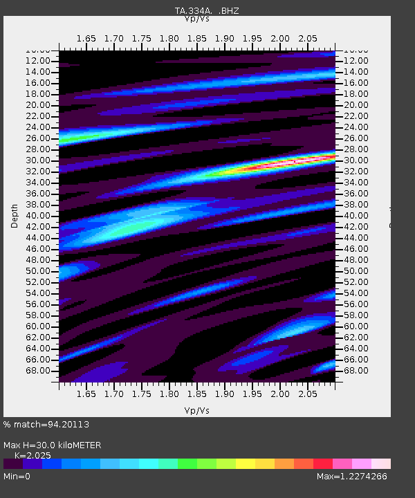
| Estimated Moho Depth: |
30.0 km |
| Estimated Crust Vp/Vs: |
2.03 |
| Assumed Crust Vp: |
6.498 km/s |
| Estimated Crust Vs: |
3.209 km/s |
| Estimated Crust Poisson's Ratio: |
0.34 |
|
| Radial Match: |
94.20113 % |
| Radial Bump: |
400 |
| Transverse Match: |
79.15919 % |
| Transverse Bump: |
400 |
| SOD ConfigId: |
319893 |
| Insert Time: |
2011-01-05 14:51:22.610 +0000 |
| GWidth: |
2.5 |
| Max Bumps: |
400 |
| Tol: |
0.001 |
|
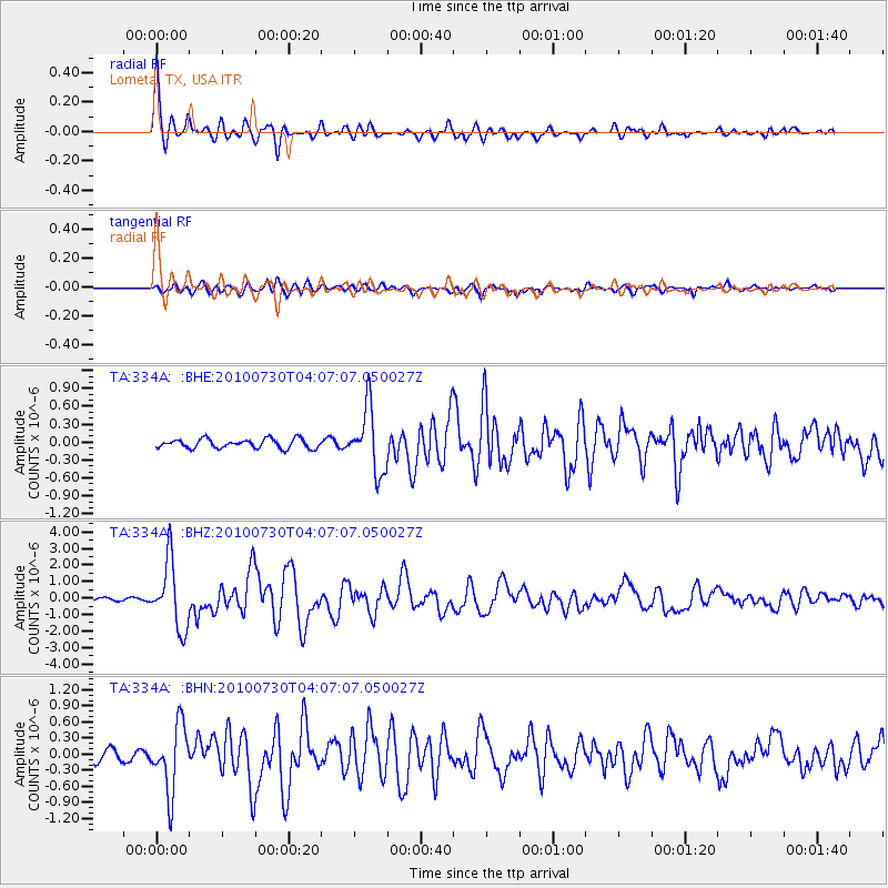
Signal To Noise
| Channel | StoN | STA | LTA |
| TA:334A: :BHZ:20100730T04:07:07.050027Z | 30.291573 | 2.0197167E-6 | 6.667587E-8 |
| TA:334A: :BHN:20100730T04:07:07.050027Z | 7.0351567 | 6.170149E-7 | 8.77045E-8 |
| TA:334A: :BHE:20100730T04:07:07.050027Z | 6.9548154 | 5.3401044E-7 | 7.678283E-8 |
| Arrivals |
| Ps | 4.9 SECOND |
| PpPs | 14 SECOND |
| PsPs/PpSs | 18 SECOND |


