You are here: Home > Network List > TA - USArray Transportable Network (new EarthScope stations) Stations List
> Station 134A White-Moore Ranch, Lipan, TX, USA > Earthquake Result Viewer
134A White-Moore Ranch, Lipan, TX, USA - Earthquake Result Viewer
| Earthquake location: |
Off East Coast Of Kamchatka |
| Earthquake latitude/longitude: |
52.5/159.8 |
| Earthquake time(UTC): |
2010/07/30 (211) 03:56:13 GMT |
| Earthquake Depth: |
23 km |
| Earthquake Magnitude: |
6.1 MB, 6.3 MS, 6.3 MW, 6.3 MW |
| Earthquake Catalog/Contributor: |
WHDF/NEIC |
|
| Network: |
TA USArray Transportable Network (new EarthScope stations) |
| Station: |
134A White-Moore Ranch, Lipan, TX, USA |
| Lat/Lon: |
32.57 N/98.08 W |
| Elevation: |
297 m |
|
| Distance: |
71.6 deg |
| Az: |
60.487 deg |
| Baz: |
320.941 deg |
| Ray Param: |
0.054207485 |
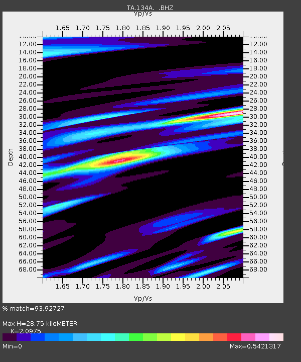
| Estimated Moho Depth: |
28.75 km |
| Estimated Crust Vp/Vs: |
2.10 |
| Assumed Crust Vp: |
6.426 km/s |
| Estimated Crust Vs: |
3.064 km/s |
| Estimated Crust Poisson's Ratio: |
0.35 |
|
| Radial Match: |
93.92727 % |
| Radial Bump: |
370 |
| Transverse Match: |
78.96068 % |
| Transverse Bump: |
400 |
| SOD ConfigId: |
319893 |
| Insert Time: |
2011-01-05 14:51:34.324 +0000 |
| GWidth: |
2.5 |
| Max Bumps: |
400 |
| Tol: |
0.001 |
|
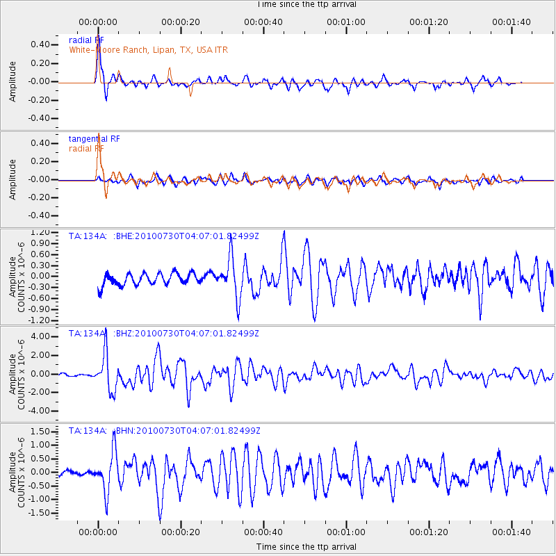
Signal To Noise
| Channel | StoN | STA | LTA |
| TA:134A: :BHZ:20100730T04:07:01.82499Z | 16.828445 | 2.0486784E-6 | 1.21739E-7 |
| TA:134A: :BHN:20100730T04:07:01.82499Z | 7.162123 | 7.630802E-7 | 1.0654385E-7 |
| TA:134A: :BHE:20100730T04:07:01.82499Z | 3.5204678 | 5.624153E-7 | 1.5975586E-7 |
| Arrivals |
| Ps | 5.1 SECOND |
| PpPs | 13 SECOND |
| PsPs/PpSs | 19 SECOND |


