You are here: Home > Network List > TA - USArray Transportable Network (new EarthScope stations) Stations List
> Station 535A Dale, TX, USA > Earthquake Result Viewer
535A Dale, TX, USA - Earthquake Result Viewer
| Earthquake location: |
Off East Coast Of Kamchatka |
| Earthquake latitude/longitude: |
52.5/159.8 |
| Earthquake time(UTC): |
2010/07/30 (211) 03:56:13 GMT |
| Earthquake Depth: |
23 km |
| Earthquake Magnitude: |
6.1 MB, 6.3 MS, 6.3 MW, 6.3 MW |
| Earthquake Catalog/Contributor: |
WHDF/NEIC |
|
| Network: |
TA USArray Transportable Network (new EarthScope stations) |
| Station: |
535A Dale, TX, USA |
| Lat/Lon: |
30.03 N/97.57 W |
| Elevation: |
170 m |
|
| Distance: |
73.8 deg |
| Az: |
61.793 deg |
| Baz: |
321.593 deg |
| Ray Param: |
0.0527166 |
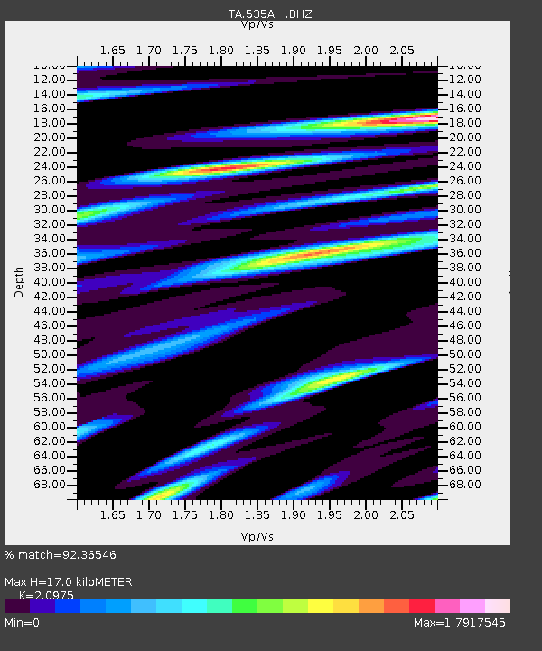
| Estimated Moho Depth: |
17.0 km |
| Estimated Crust Vp/Vs: |
2.10 |
| Assumed Crust Vp: |
6.347 km/s |
| Estimated Crust Vs: |
3.026 km/s |
| Estimated Crust Poisson's Ratio: |
0.35 |
|
| Radial Match: |
92.36546 % |
| Radial Bump: |
400 |
| Transverse Match: |
82.50232 % |
| Transverse Bump: |
400 |
| SOD ConfigId: |
319893 |
| Insert Time: |
2011-01-05 14:52:24.778 +0000 |
| GWidth: |
2.5 |
| Max Bumps: |
400 |
| Tol: |
0.001 |
|

Signal To Noise
| Channel | StoN | STA | LTA |
| TA:535A: :BHZ:20100730T04:07:15.150002Z | 22.035254 | 1.8764E-6 | 8.5154454E-8 |
| TA:535A: :BHN:20100730T04:07:15.150002Z | 11.711217 | 1.3067092E-6 | 1.11577585E-7 |
| TA:535A: :BHE:20100730T04:07:15.150002Z | 3.240749 | 6.213581E-7 | 1.9173287E-7 |
| Arrivals |
| Ps | 3.0 SECOND |
| PpPs | 8.1 SECOND |
| PsPs/PpSs | 11 SECOND |


