You are here: Home > Network List > IW - Intermountain West Stations List
> Station MOOW Moose Ponds, Wyoming, USA > Earthquake Result Viewer
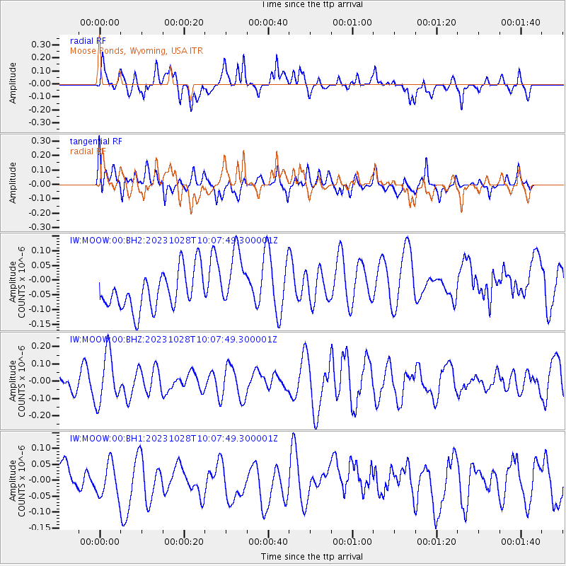
MOOW Moose Ponds, Wyoming, USA - Earthquake Result Viewer
*The percent match for this event was below the threshold and hence no stack was calculated.
| Earthquake location: |
Vanuatu Islands |
| Earthquake latitude/longitude: |
-13.1/167.1 |
| Earthquake time(UTC): |
2023/10/28 (301) 09:55:28 GMT |
| Earthquake Depth: |
201 km |
| Earthquake Magnitude: |
5.6 mww |
| Earthquake Catalog/Contributor: |
NEIC PDE/us |
|
| Network: |
IW Intermountain West |
| Station: |
MOOW Moose Ponds, Wyoming, USA |
| Lat/Lon: |
43.75 N/110.74 W |
| Elevation: |
2128 m |
|
| Distance: |
93.4 deg |
| Az: |
45.994 deg |
| Baz: |
255.229 deg |
| Ray Param: |
$rayparam |
*The percent match for this event was below the threshold and hence was not used in the summary stack. |
|
| Radial Match: |
42.11324 % |
| Radial Bump: |
400 |
| Transverse Match: |
40.006916 % |
| Transverse Bump: |
400 |
| SOD ConfigId: |
31937991 |
| Insert Time: |
2023-11-11 10:10:19.299 +0000 |
| GWidth: |
2.5 |
| Max Bumps: |
400 |
| Tol: |
0.001 |
|
Signal To Noise
| Channel | StoN | STA | LTA |
| IW:MOOW:00:BHZ:20231028T10:07:49.300001Z | 1.7185595 | 1.4647189E-7 | 8.522945E-8 |
| IW:MOOW:00:BH1:20231028T10:07:49.300001Z | 1.0727918 | 6.1097566E-8 | 5.6951933E-8 |
| IW:MOOW:00:BH2:20231028T10:07:49.300001Z | 1.595418 | 1.03053125E-7 | 6.459318E-8 |
| Arrivals |
| Ps | |
| PpPs | |
| PsPs/PpSs | |


