You are here: Home > Network List > TA - USArray Transportable Network (new EarthScope stations) Stations List
> Station 536A Bastrop, TX, USA > Earthquake Result Viewer
536A Bastrop, TX, USA - Earthquake Result Viewer

| Earthquake location: |
Off East Coast Of Kamchatka |
| Earthquake latitude/longitude: |
52.5/159.8 |
| Earthquake time(UTC): |
2010/07/30 (211) 03:56:13 GMT |
| Earthquake Depth: |
23 km |
| Earthquake Magnitude: |
6.1 MB, 6.3 MS, 6.3 MW, 6.3 MW |
| Earthquake Catalog/Contributor: |
WHDF/NEIC |
|
| Network: |
TA USArray Transportable Network (new EarthScope stations) |
| Station: |
536A Bastrop, TX, USA |
| Lat/Lon: |
30.08 N/97.07 W |
| Elevation: |
115 m |
|
| Distance: |
74.1 deg |
| Az: |
61.405 deg |
| Baz: |
321.737 deg |
| Ray Param: |
0.05255827 |
| Estimated Moho Depth: |
12.75 km |
| Estimated Crust Vp/Vs: |
2.08 |
| Assumed Crust Vp: |
6.347 km/s |
| Estimated Crust Vs: |
3.059 km/s |
| Estimated Crust Poisson's Ratio: |
0.35 |
|
| Radial Match: |
90.01165 % |
| Radial Bump: |
400 |
| Transverse Match: |
87.83285 % |
| Transverse Bump: |
400 |
| SOD ConfigId: |
319893 |
| Insert Time: |
2011-01-05 14:53:26.383 +0000 |
| GWidth: |
2.5 |
| Max Bumps: |
400 |
| Tol: |
0.001 |
|
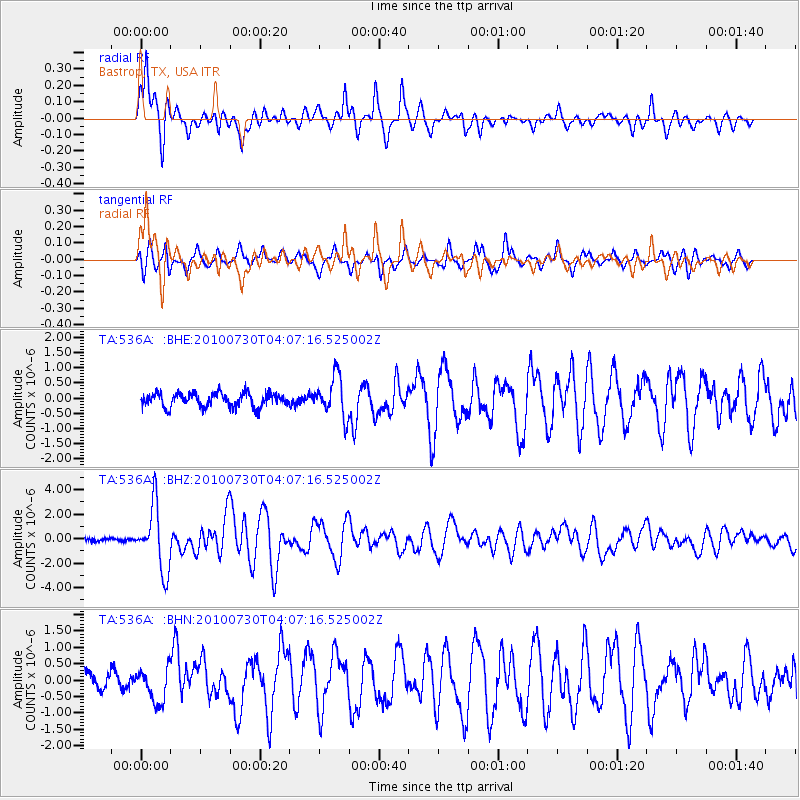
Signal To Noise
| Channel | StoN | STA | LTA |
| TA:536A: :BHZ:20100730T04:07:16.525002Z | 19.876572 | 2.599016E-6 | 1.3075775E-7 |
| TA:536A: :BHN:20100730T04:07:16.525002Z | 1.8611139 | 5.2162676E-7 | 2.8027665E-7 |
| TA:536A: :BHE:20100730T04:07:16.525002Z | 2.8934677 | 6.535125E-7 | 2.2585786E-7 |
| Arrivals |
| Ps | 2.2 SECOND |
| PpPs | 6.0 SECOND |
| PsPs/PpSs | 8.2 SECOND |


