You are here: Home > Network List > TA - USArray Transportable Network (new EarthScope stations) Stations List
> Station 336A Riesel, TX, USA > Earthquake Result Viewer
336A Riesel, TX, USA - Earthquake Result Viewer
| Earthquake location: |
Off East Coast Of Kamchatka |
| Earthquake latitude/longitude: |
52.5/159.8 |
| Earthquake time(UTC): |
2010/07/30 (211) 03:56:13 GMT |
| Earthquake Depth: |
23 km |
| Earthquake Magnitude: |
6.1 MB, 6.3 MS, 6.3 MW, 6.3 MW |
| Earthquake Catalog/Contributor: |
WHDF/NEIC |
|
| Network: |
TA USArray Transportable Network (new EarthScope stations) |
| Station: |
336A Riesel, TX, USA |
| Lat/Lon: |
31.39 N/96.84 W |
| Elevation: |
140 m |
|
| Distance: |
73.2 deg |
| Az: |
60.405 deg |
| Baz: |
321.567 deg |
| Ray Param: |
0.053162623 |
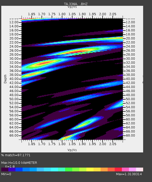
| Estimated Moho Depth: |
10.0 km |
| Estimated Crust Vp/Vs: |
1.60 |
| Assumed Crust Vp: |
6.347 km/s |
| Estimated Crust Vs: |
3.967 km/s |
| Estimated Crust Poisson's Ratio: |
0.18 |
|
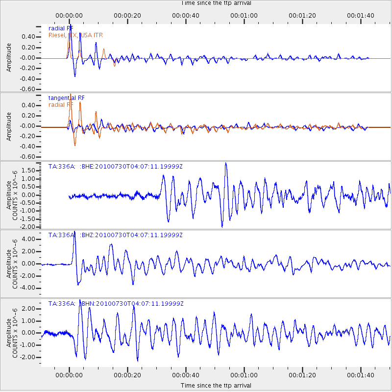
| Radial Match: |
97.1771 % |
| Radial Bump: |
248 |
| Transverse Match: |
87.07143 % |
| Transverse Bump: |
400 |
| SOD ConfigId: |
319893 |
| Insert Time: |
2011-01-05 14:54:02.266 +0000 |
| GWidth: |
2.5 |
| Max Bumps: |
400 |
| Tol: |
0.001 |
|
Signal To Noise
| Channel | StoN | STA | LTA |
| TA:336A: :BHZ:20100730T04:07:11.19999Z | 39.063812 | 2.2849692E-6 | 5.8493242E-8 |
| TA:336A: :BHN:20100730T04:07:11.19999Z | 9.191164 | 1.211394E-6 | 1.3179984E-7 |
| TA:336A: :BHE:20100730T04:07:11.19999Z | 9.191164 | 7.786389E-7 | 8.471602E-8 |
| Arrivals |
| Ps | 1.0 SECOND |
| PpPs | 3.9 SECOND |
| PsPs/PpSs | 4.9 SECOND |


