You are here: Home > Network List > TA - USArray Transportable Network (new EarthScope stations) Stations List
> Station 340A Bronson, TX, USA > Earthquake Result Viewer
340A Bronson, TX, USA - Earthquake Result Viewer
| Earthquake location: |
Off East Coast Of Kamchatka |
| Earthquake latitude/longitude: |
52.5/159.8 |
| Earthquake time(UTC): |
2010/07/30 (211) 03:56:13 GMT |
| Earthquake Depth: |
23 km |
| Earthquake Magnitude: |
6.1 MB, 6.3 MS, 6.3 MW, 6.3 MW |
| Earthquake Catalog/Contributor: |
WHDF/NEIC |
|
| Network: |
TA USArray Transportable Network (new EarthScope stations) |
| Station: |
340A Bronson, TX, USA |
| Lat/Lon: |
31.42 N/93.89 W |
| Elevation: |
57 m |
|
| Distance: |
74.7 deg |
| Az: |
58.313 deg |
| Baz: |
322.52 deg |
| Ray Param: |
0.05213926 |
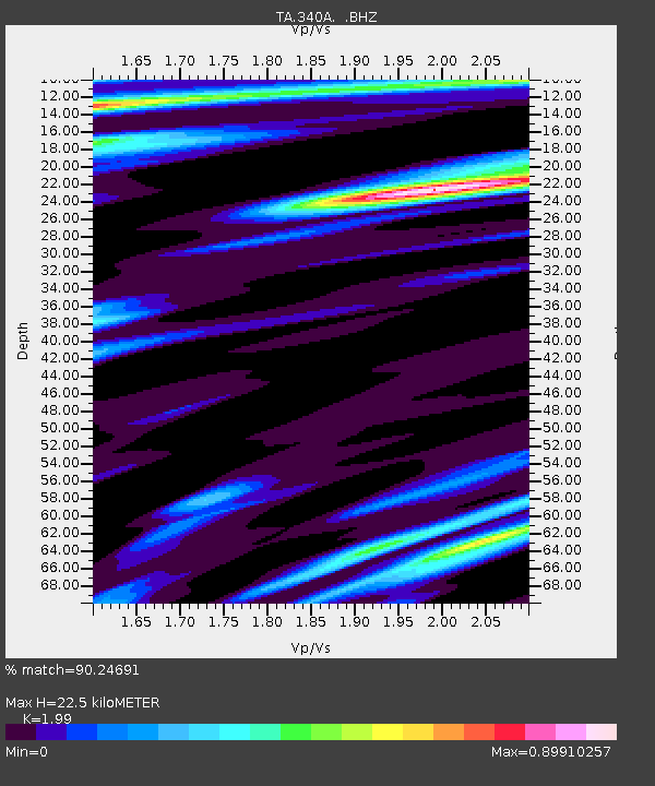
| Estimated Moho Depth: |
22.5 km |
| Estimated Crust Vp/Vs: |
1.99 |
| Assumed Crust Vp: |
6.065 km/s |
| Estimated Crust Vs: |
3.048 km/s |
| Estimated Crust Poisson's Ratio: |
0.33 |
|
| Radial Match: |
90.24691 % |
| Radial Bump: |
400 |
| Transverse Match: |
85.70547 % |
| Transverse Bump: |
397 |
| SOD ConfigId: |
319893 |
| Insert Time: |
2011-01-05 14:54:31.636 +0000 |
| GWidth: |
2.5 |
| Max Bumps: |
400 |
| Tol: |
0.001 |
|

Signal To Noise
| Channel | StoN | STA | LTA |
| TA:340A: :BHZ:20100730T04:07:20.124978Z | 36.677322 | 3.4189754E-6 | 9.3217686E-8 |
| TA:340A: :BHN:20100730T04:07:20.124978Z | 4.1004066 | 7.560619E-7 | 1.8438706E-7 |
| TA:340A: :BHE:20100730T04:07:20.124978Z | 2.1849797 | 4.833397E-7 | 2.2121017E-7 |
| Arrivals |
| Ps | 3.8 SECOND |
| PpPs | 11 SECOND |
| PsPs/PpSs | 15 SECOND |


