You are here: Home > Network List > TA - USArray Transportable Network (new EarthScope stations) Stations List
> Station 239A Gary, TX, USA > Earthquake Result Viewer
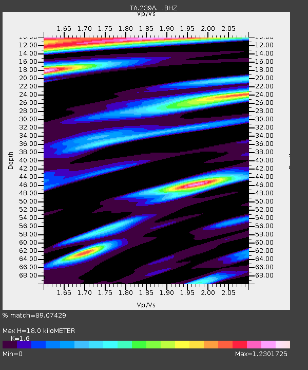
239A Gary, TX, USA - Earthquake Result Viewer
| Earthquake location: |
Off East Coast Of Kamchatka |
| Earthquake latitude/longitude: |
52.5/159.8 |
| Earthquake time(UTC): |
2010/07/30 (211) 03:56:13 GMT |
| Earthquake Depth: |
23 km |
| Earthquake Magnitude: |
6.1 MB, 6.3 MS, 6.3 MW, 6.3 MW |
| Earthquake Catalog/Contributor: |
WHDF/NEIC |
|
| Network: |
TA USArray Transportable Network (new EarthScope stations) |
| Station: |
239A Gary, TX, USA |
| Lat/Lon: |
32.02 N/94.47 W |
| Elevation: |
100 m |
|
| Distance: |
73.9 deg |
| Az: |
58.34 deg |
| Baz: |
322.223 deg |
| Ray Param: |
0.052661397 |
| Estimated Moho Depth: |
18.0 km |
| Estimated Crust Vp/Vs: |
1.60 |
| Assumed Crust Vp: |
6.245 km/s |
| Estimated Crust Vs: |
3.903 km/s |
| Estimated Crust Poisson's Ratio: |
0.18 |
|
| Radial Match: |
89.07429 % |
| Radial Bump: |
400 |
| Transverse Match: |
66.922585 % |
| Transverse Bump: |
400 |
| SOD ConfigId: |
319893 |
| Insert Time: |
2011-01-05 14:54:38.912 +0000 |
| GWidth: |
2.5 |
| Max Bumps: |
400 |
| Tol: |
0.001 |
|

Signal To Noise
| Channel | StoN | STA | LTA |
| TA:239A: :BHZ:20100730T04:07:15.624978Z | 13.899158 | 2.3104678E-6 | 1.6623078E-7 |
| TA:239A: :BHN:20100730T04:07:15.624978Z | 3.100159 | 6.168255E-7 | 1.9896576E-7 |
| TA:239A: :BHE:20100730T04:07:15.624978Z | 1.5834368 | 5.2291995E-7 | 3.3024364E-7 |
| Arrivals |
| Ps | 1.8 SECOND |
| PpPs | 7.2 SECOND |
| PsPs/PpSs | 9.0 SECOND |


