You are here: Home > Network List > US - United States National Seismic Network Stations List
> Station HAWA Hanford, Washington, USA > Earthquake Result Viewer
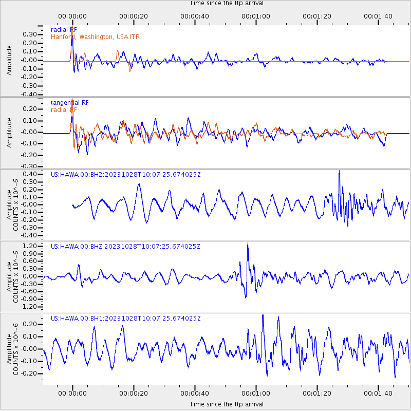
HAWA Hanford, Washington, USA - Earthquake Result Viewer
*The percent match for this event was below the threshold and hence no stack was calculated.
| Earthquake location: |
Vanuatu Islands |
| Earthquake latitude/longitude: |
-13.1/167.1 |
| Earthquake time(UTC): |
2023/10/28 (301) 09:55:28 GMT |
| Earthquake Depth: |
201 km |
| Earthquake Magnitude: |
5.6 mww |
| Earthquake Catalog/Contributor: |
NEIC PDE/us |
|
| Network: |
US United States National Seismic Network |
| Station: |
HAWA Hanford, Washington, USA |
| Lat/Lon: |
46.39 N/119.53 W |
| Elevation: |
364 m |
|
| Distance: |
88.3 deg |
| Az: |
41.577 deg |
| Baz: |
249.087 deg |
| Ray Param: |
$rayparam |
*The percent match for this event was below the threshold and hence was not used in the summary stack. |
|
| Radial Match: |
35.799286 % |
| Radial Bump: |
367 |
| Transverse Match: |
56.521225 % |
| Transverse Bump: |
400 |
| SOD ConfigId: |
31937991 |
| Insert Time: |
2023-11-11 10:16:11.976 +0000 |
| GWidth: |
2.5 |
| Max Bumps: |
400 |
| Tol: |
0.001 |
|
Signal To Noise
| Channel | StoN | STA | LTA |
| US:HAWA:00:BHZ:20231028T10:07:25.674025Z | 2.5075548 | 2.1132901E-7 | 8.427693E-8 |
| US:HAWA:00:BH1:20231028T10:07:25.674025Z | 0.83623886 | 5.960783E-8 | 7.128086E-8 |
| US:HAWA:00:BH2:20231028T10:07:25.674025Z | 1.0200188 | 1.06868114E-7 | 1.0477073E-7 |
| Arrivals |
| Ps | |
| PpPs | |
| PsPs/PpSs | |


