You are here: Home > Network List > TA - USArray Transportable Network (new EarthScope stations) Stations List
> Station W35A Tecumseh, OK, USA > Earthquake Result Viewer
W35A Tecumseh, OK, USA - Earthquake Result Viewer
| Earthquake location: |
Off East Coast Of Kamchatka |
| Earthquake latitude/longitude: |
52.5/159.8 |
| Earthquake time(UTC): |
2010/07/30 (211) 03:56:13 GMT |
| Earthquake Depth: |
23 km |
| Earthquake Magnitude: |
6.1 MB, 6.3 MS, 6.3 MW, 6.3 MW |
| Earthquake Catalog/Contributor: |
WHDF/NEIC |
|
| Network: |
TA USArray Transportable Network (new EarthScope stations) |
| Station: |
W35A Tecumseh, OK, USA |
| Lat/Lon: |
35.15 N/96.87 W |
| Elevation: |
322 m |
|
| Distance: |
70.2 deg |
| Az: |
57.945 deg |
| Baz: |
320.778 deg |
| Ray Param: |
0.055103324 |
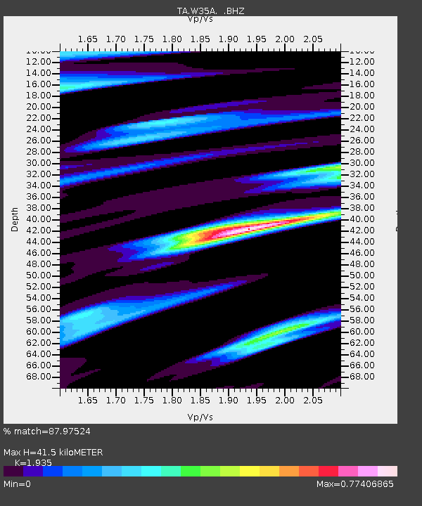
| Estimated Moho Depth: |
41.5 km |
| Estimated Crust Vp/Vs: |
1.93 |
| Assumed Crust Vp: |
6.426 km/s |
| Estimated Crust Vs: |
3.321 km/s |
| Estimated Crust Poisson's Ratio: |
0.32 |
|
| Radial Match: |
87.97524 % |
| Radial Bump: |
311 |
| Transverse Match: |
85.39887 % |
| Transverse Bump: |
400 |
| SOD ConfigId: |
319893 |
| Insert Time: |
2011-01-05 14:55:59.705 +0000 |
| GWidth: |
2.5 |
| Max Bumps: |
400 |
| Tol: |
0.001 |
|

Signal To Noise
| Channel | StoN | STA | LTA |
| TA:W35A: :BHZ:20100730T04:06:53.550027Z | 18.034365 | 2.6254515E-6 | 1.4558049E-7 |
| TA:W35A: :BHN:20100730T04:06:53.550027Z | 3.9148762 | 9.1396714E-7 | 2.3346003E-7 |
| TA:W35A: :BHE:20100730T04:06:53.550027Z | 3.5752516 | 6.418226E-7 | 1.7951818E-7 |
| Arrivals |
| Ps | 6.2 SECOND |
| PpPs | 18 SECOND |
| PsPs/PpSs | 25 SECOND |


