You are here: Home > Network List > TA - USArray Transportable Network (new EarthScope stations) Stations List
> Station X35A Drake, OK, USA > Earthquake Result Viewer
X35A Drake, OK, USA - Earthquake Result Viewer
| Earthquake location: |
Off East Coast Of Kamchatka |
| Earthquake latitude/longitude: |
52.5/159.8 |
| Earthquake time(UTC): |
2010/07/30 (211) 03:56:13 GMT |
| Earthquake Depth: |
23 km |
| Earthquake Magnitude: |
6.1 MB, 6.3 MS, 6.3 MW, 6.3 MW |
| Earthquake Catalog/Contributor: |
WHDF/NEIC |
|
| Network: |
TA USArray Transportable Network (new EarthScope stations) |
| Station: |
X35A Drake, OK, USA |
| Lat/Lon: |
34.40 N/96.97 W |
| Elevation: |
300 m |
|
| Distance: |
70.7 deg |
| Az: |
58.515 deg |
| Baz: |
320.912 deg |
| Ray Param: |
0.054751128 |
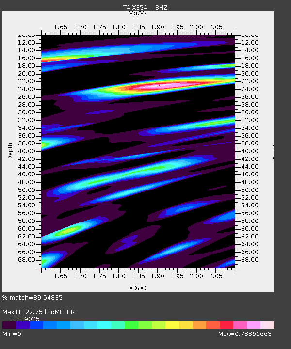
| Estimated Moho Depth: |
22.75 km |
| Estimated Crust Vp/Vs: |
1.90 |
| Assumed Crust Vp: |
6.426 km/s |
| Estimated Crust Vs: |
3.378 km/s |
| Estimated Crust Poisson's Ratio: |
0.31 |
|
| Radial Match: |
89.54835 % |
| Radial Bump: |
400 |
| Transverse Match: |
90.91053 % |
| Transverse Bump: |
400 |
| SOD ConfigId: |
319893 |
| Insert Time: |
2011-01-05 14:56:11.832 +0000 |
| GWidth: |
2.5 |
| Max Bumps: |
400 |
| Tol: |
0.001 |
|
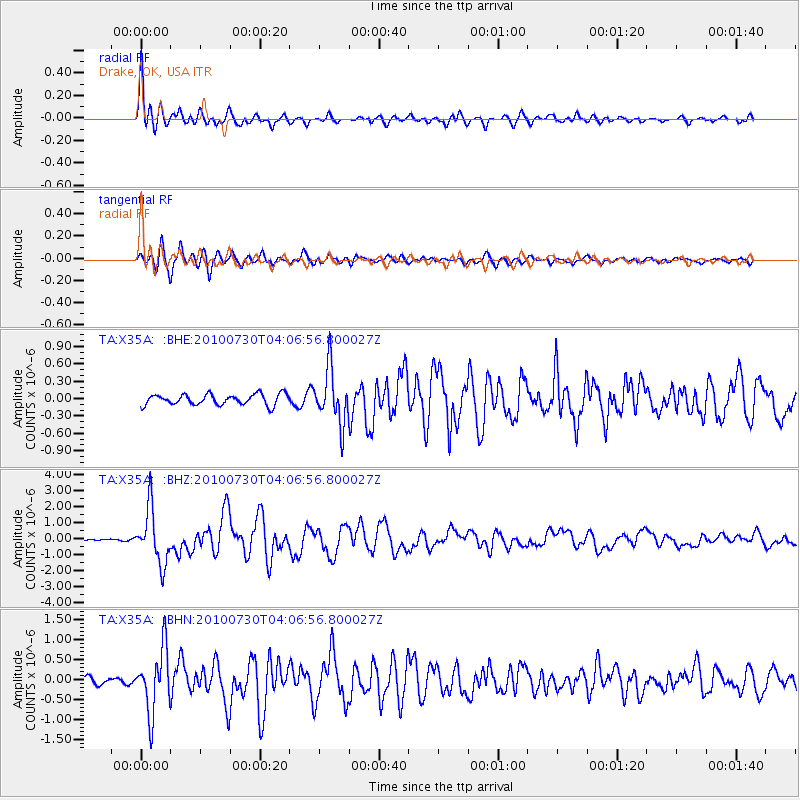
Signal To Noise
| Channel | StoN | STA | LTA |
| TA:X35A: :BHZ:20100730T04:06:56.800027Z | 27.859575 | 1.7242135E-6 | 6.188944E-8 |
| TA:X35A: :BHN:20100730T04:06:56.800027Z | 5.1649456 | 7.911916E-7 | 1.5318489E-7 |
| TA:X35A: :BHE:20100730T04:06:56.800027Z | 5.0709643 | 4.7194155E-7 | 9.306742E-8 |
| Arrivals |
| Ps | 3.3 SECOND |
| PpPs | 9.9 SECOND |
| PsPs/PpSs | 13 SECOND |


