You are here: Home > Network List > TA - USArray Transportable Network (new EarthScope stations) Stations List
> Station Q34A Chapman, KS, USA > Earthquake Result Viewer
Q34A Chapman, KS, USA - Earthquake Result Viewer
| Earthquake location: |
Off East Coast Of Kamchatka |
| Earthquake latitude/longitude: |
52.5/159.8 |
| Earthquake time(UTC): |
2010/07/30 (211) 03:56:13 GMT |
| Earthquake Depth: |
23 km |
| Earthquake Magnitude: |
6.1 MB, 6.3 MS, 6.3 MW, 6.3 MW |
| Earthquake Catalog/Contributor: |
WHDF/NEIC |
|
| Network: |
TA USArray Transportable Network (new EarthScope stations) |
| Station: |
Q34A Chapman, KS, USA |
| Lat/Lon: |
38.92 N/96.94 W |
| Elevation: |
378 m |
|
| Distance: |
67.3 deg |
| Az: |
55.411 deg |
| Baz: |
319.819 deg |
| Ray Param: |
0.0570271 |
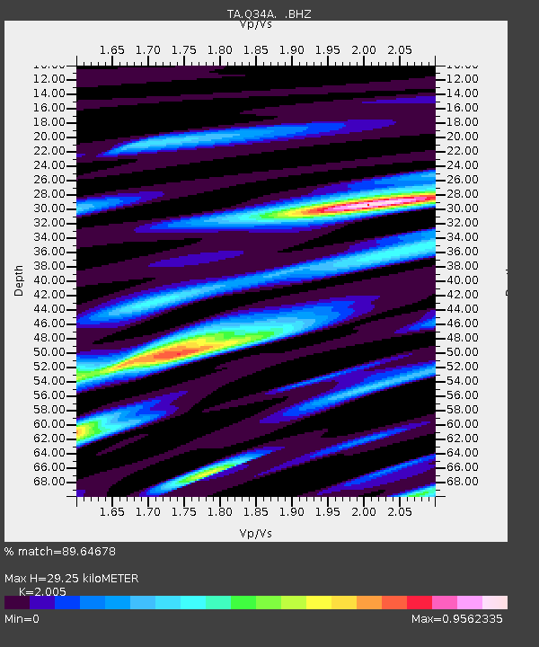
| Estimated Moho Depth: |
29.25 km |
| Estimated Crust Vp/Vs: |
2.01 |
| Assumed Crust Vp: |
6.483 km/s |
| Estimated Crust Vs: |
3.233 km/s |
| Estimated Crust Poisson's Ratio: |
0.33 |
|
| Radial Match: |
89.64678 % |
| Radial Bump: |
400 |
| Transverse Match: |
80.36652 % |
| Transverse Bump: |
400 |
| SOD ConfigId: |
319893 |
| Insert Time: |
2011-01-05 14:57:51.997 +0000 |
| GWidth: |
2.5 |
| Max Bumps: |
400 |
| Tol: |
0.001 |
|
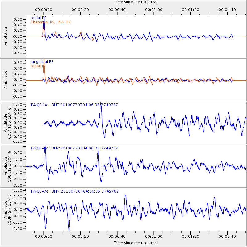
Signal To Noise
| Channel | StoN | STA | LTA |
| TA:Q34A: :BHZ:20100730T04:06:35.374978Z | 9.59423 | 1.277706E-6 | 1.3317444E-7 |
| TA:Q34A: :BHN:20100730T04:06:35.374978Z | 4.3137016 | 6.168125E-7 | 1.4298914E-7 |
| TA:Q34A: :BHE:20100730T04:06:35.374978Z | 6.611721 | 6.160509E-7 | 9.317557E-8 |
| Arrivals |
| Ps | 4.7 SECOND |
| PpPs | 13 SECOND |
| PsPs/PpSs | 18 SECOND |


