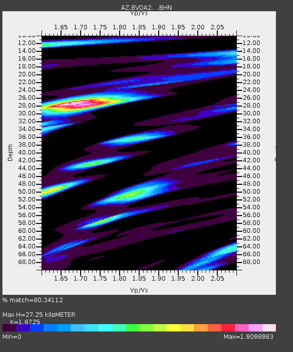
BVDA2 AZ.BVDA2 - Earthquake Result Viewer
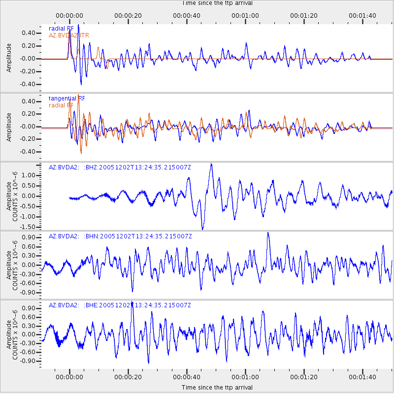
Earthquake location: Near East Coast Of Honshu, Japan
Earthquake latitude/longitude: 38.1/142.1
Earthquake time(UTC): 2005/12/02 (336) 13:13:09 GMT
Earthquake Depth: 29 km
Earthquake Magnitude: 6.1 MB, 6.3 MS, 6.5 MW, 6.4 MW
Earthquake Catalog/Contributor: WHDF/NEIC
Network: AZ ANZA Regional Network
Station: BVDA2 AZ.BVDA2
Lat/Lon: 33.33 N/116.37 W
Elevation: 0.0 m
Distance: 78.2 deg
Az: 56.933 deg
Baz: 307.833 deg
Ray Param: 0.04974945
Estimated Moho Depth: 27.25 km
Estimated Crust Vp/Vs: 1.67
Assumed Crust Vp: 6.264 km/s
Estimated Crust Vs: 3.745 km/s
Estimated Crust Poisson's Ratio: 0.22
Radial Match: 80.34112 %
Radial Bump: 400
Transverse Match: 66.6119 %
Transverse Bump: 400
SOD ConfigId: 2422
Insert Time: 2010-02-26 18:38:45.678 +0000
GWidth: 2.5
Max Bumps: 400
Tol: 0.001

Signal To Noise

ChannelStoNSTALTA
AZ:BVDA2: :BHN:20051202T13:24:35.215007Z1.65253931.5510851E-79.386072E-8
AZ:BVDA2: :BHE:20051202T13:24:35.215007Z2.0450672.8926766E-71.4144655E-7
AZ:BVDA2: :BHZ:20051202T13:24:35.215007Z1.30340481.6608651E-71.2742511E-7
Arrivals
Ps3.0 SECOND
PpPs11 SECOND
PsPs/PpSs14 SECOND